
West Mains Of Ethie


Carved Stone (Iron Age) - (Early Medieval), Long Cist (Early Medieval), Promontory Fort (Iron Age)
Site Name West Mains Of Ethie
Classification Carved Stone (Iron Age) - (Early Medieval), Long Cist (Early Medieval), Promontory Fort (Iron Age)
Canmore ID 35439
Site Number NO64NE 8
NGR NO 6928 4600
Datum OSGB36 - NGR
Permalink http://canmore.org.uk/site/35439


- Council Angus
- Parish Inverkeilor
- Former Region Tayside
- Former District Angus
- Former County Angus
NO64NE 8 6928 4600.
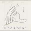
(NO 6928 4600) Promontory fort formed by triple banks 1.5m high and ditches across the base of the headland, broken by a centrally placed entrance which is approached by a causeway. Visible on RAF AP's (F21 540:986: 0170-1).
Surveyed at 1/2500.
Visited by OS (JLD) 10 June 1958
Excavations carried out by the Abertay Historical Society between 1962 and 1971 confirmed the triple defences and indicated the existence of a post-hole hut complex with associated paving in the enceinte. Small finds suggested a 2nd century occupation. A secondary structure overlay the entrance causeway and the remains of an apparently intrusive long cist were found at the outer end of the outer end of the entrance.
Three rampart sections were dug, the first, in an unspecified position revealing a revetting of large stones. The second dug in 1967 south of the entrance through which the rampart is not stated revealed two sleeper trenches for a wood or stone revetting. The infill was of upcast turf and clay topped with rubble. The third section was dug in 1970 across the inner rampart showed a stone rampart with timber supports overlying a clay bank. The inner ditch was u-shaped with a deep'slat' at the bottom; the middle ditch was rock cut roughly u-shaped and the shape of the outer ditch was ascertained but is not stated.
The entrance passage which was part of the original structure, had a central doorcheck and was well paved with indications to wear. The internal settlement complex was accompanied by stone-lined and paved storage pits and at best one hearth.
Small finds included a Roman 2nd century bronze fibula, and also datable to the first half of the second century a bronze pennanular brooch, a section of glass armlet and a yellow glass bead similar to finds from Newstead.
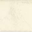
During excavations in July and August 1965, a shaped slab of sandstone bearing an incised design was found.
J Wilson 1963; 1964; 1965; 1966; 1967; 1968; 1969; 1970; 1971; A S Robertson 1970; D R Wilson 1972
Field Visit (6 May 1957)
This site was included within the RCAHMS Marginal Land Survey (1950-1962), an unpublished rescue project. Site descriptions, organised by county, are available to view online - see the searchable PDF in 'Digital Items'. These vary from short notes, to lengthy and full descriptions. Contemporary plane-table surveys and inked drawings, where available, can be viewed online in most cases - see 'Digital Images'. The original typecripts, notebooks and drawings can also be viewed in the RCAHMS search room.
Information from RCAHMS (GFG) 19 July 2013.
Reference (1963)
This site is noted in the ‘List of monuments discovered during the survey of marginal land (1956-8)’, published in Vol. 1 of the RCAHMS Inventory of Stirlingshire. The 26 monuments were listed by their name, classification, parish and county, and the list also includes an indication of whether they had been planned (P), whether they were visible only as a cropmark (C), and whether they were worthy of preservation (*).
Information from RCAHMS (GFG) 30 October 2012.
Field Visit (March 1978)
West Mains of Ethie NO 692 460 NO64NE 8
A coastal promontory fort defended by three ramparts. Between 1962 and 1971 trenches were excavated across the defences and entrance; the remains of paving and timber structures were located in the interior.
RCAHMS 1978, visited March 1978
(Coutts 1970, 38, no. 28; DES, 1971, 2)
Note (1978)
West Mains of Ethie NO 692 460 NO64NE 8
A long cist was discovered during excavations of the fort.
RCAHMS 1978
(DES, 1966, 3)
Note (3 June 2015 - 25 October 2016)
The remains of this small fortification are situated on the coastal cliffs SSE of West Mains of Ethie. First discovered during the RCAHMS Survey of Marginal Lands, and excavated by the Abertay Historical Society 1962-71 (Wilson 1980), its defences comprise three ramparts with external ditches, which bar access from the W to an irregular area measuring a maximum of 53m from E to W by 24m transversely (0.1ha). The defences are drawn in a shallow arc across the neck on the WNW, forming a belt about 33m deep, and are pierced by a central entrance. The description of what was found in the areas excavated is confusing, but showed that where best preserved the innermost rampart is about 2.4m in thickness, and is faced inside and out with large boulders. Evidence of timberwork was also found beneath it, however, comprising two parallel lengths of palisade trench, the inner rather slighter than the outer, and several post-holes; a penannular brooch was recovered from the bottom of the outer trench. For the most part the outer ramparts were little more than ridges of undisturbed clay separated by ditches between 2.4m and 3.6m in breadth and from 1.5m to 1.8m in depth. The entrance causeway had two layers of metalling, and a glass bead and a fragment of a blue glass bangle were recovered from between them. The entrance through the inner rampart was paved and there were also patches of paving and a scatter of pits and post-holes in the interior almost certainly representing several periods of construction; two hearths were found immediately behind the rampart. The post-holes cannot be resolved into any clear pattern, but a shallow depression 5m in diameter identified on the S on the RCAHMS survey seems to have been a clay-floored structure with an enclosing bank. Other finds from the excavations include two stone lamps, a decorated stone, an iron sickle, a fragment of crucible, a bronze fibula, a sherd of samian ware and several coarse stone tools and fragments of rotary querns. The glass bead, bangle, the sherd of smaian and the fibula and brooch all date from the 1st and 2nd centuries AD.
Information from An Atlas of Hillforts of Great Britain and Ireland – 25 October 2016. Atlas of Hillforts SC3093

