|
Photographs and Off-line Digital Images |
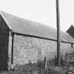
A 10901 |
List C Survey |
View of farm building. |
1975 |
Item Level |
|
|
Photographs and Off-line Digital Images |
DP 124381 |
Buildings at Risk Register |
Kirkton Farm Building Gable ends |
30/6/2009 |
Item Level |
|
|
Photographs and Off-line Digital Images |
DP 124382 |
Buildings at Risk Register |
Kirkton Farm Building Side elevation |
30/6/2009 |
Item Level |
|
|
Photographs and Off-line Digital Images |
DP 124383 |
Buildings at Risk Register |
Kirkton Farm Building Corner elevation |
30/6/2009 |
Item Level |
|
|
Photographs and Off-line Digital Images |
DP 124384 |
Buildings at Risk Register |
Kirkton Farm Building Approach |
30/6/2009 |
Item Level |
|
|
Photographs and Off-line Digital Images |
DP 149767 |
Buildings at Risk Register |
South West elevation |
23/10/2012 |
Item Level |
|
|
Photographs and Off-line Digital Images |
DP 149768 |
Buildings at Risk Register |
South West elevation |
23/10/2012 |
Item Level |
|
|
Photographs and Off-line Digital Images |
DP 149769 |
Buildings at Risk Register |
Fire gutted section |
23/10/2012 |
Item Level |
|
|
Photographs and Off-line Digital Images |
DP 149770 |
Buildings at Risk Register |
Southern range |
23/10/2012 |
Item Level |
|
|
Photographs and Off-line Digital Images |
DP 240320 |
Records of the Royal Commission on the Ancient and Historical Monuments of Scotland (RCAHMS), Edinbu |
From East |
30/6/2016 |
Item Level |
|
|
Photographs and Off-line Digital Images |
DP 240321 |
Records of the Royal Commission on the Ancient and Historical Monuments of Scotland (RCAHMS), Edinbu |
From North East |
30/6/2016 |
Item Level |
|
 |
On-line Digital Images |
SC 1652653 |
List C Survey |
View of farm building. |
1975 |
Item Level |
|
 |
On-line Digital Images |
SC 2410045 |
Records of the Ordnance Survey, Southampton, Hampshire, England |
Inverkeilor, Kirkton Farm, Farm Building, NO64NE 38, Ordnance Survey index card, Recto |
1958 |
Item Level |
|


