
Crail, Shoregate, Harbour


Harbour (16th Century)
Site Name Crail, Shoregate, Harbour
Classification Harbour (16th Century)
Alternative Name(s) Crail Harbour; Firth Of Forth; Outer Forth Estuary
Canmore ID 35336
Site Number NO60NW 31
NGR NO 61159 07405
NGR Description Centred NO 61159 07405
Datum OSGB36 - NGR
Permalink http://canmore.org.uk/site/35336


- Council Fife
- Parish Crail
- Former Region Fife
- Former District North East Fife
- Former County Fife
NO60NW 31.00 centred 61159 07405
Piers [NAT]
Harbour [NAT]
(at NO 611 073)
OS 1:10,000 map, 1972.
Location formerly entered as NO 611 073.
NO60NW 31.01 NO 6114 0735 hand crane [Location unverified]
NO60NW 31.02 NO 6124 0745 to NO 6125 0742 watching brief
NO60NW 31.03 NO 61156 07372 to NO c. 61162 07409 West Pier
NO60NW 31.04 NO 61147 07360 to NO 61205 07352 to NO c. 61237 07376 South Pier
NO60NW 31.05 NO 61211 07367 Slipway
See also:
NO60NW 25 NO 61047 07395 Lower Leading Light
NO60NW 26 NO 61021 07409 Upper Leading Light
NO60NW 151 NO 61222 07426 38 Shoregate, Harbour Office
(Location cited as NO 611 073). Crail, Fife: the early history of Crail is obscured by the existence of a somewhat shadowy 'old harbour', and by the uncertainty that results therefrom in the referring of records to one site or another. There is no positive guide, for example, to the position of the 'havin' of 1498. The expression 'cum lie harberies novis et antiquis' used in a charter of 1635 may or may not be simply a legal formula, but in 1845 the old harbour was placed definitely in Roome Bay [Roome Rocks: NO 621 077], about half a mile distant on the NE, but as no evidence has been found for harbour-construction there, this bay probably served only as a natural haven. On this showing, references to structure should all apply to the harbour below the town, but this raises the further difficulty that, whereas the 'building of the bulwark, port and havin' was only authorised in 1575, two earlier documents, of 1512 and 1537 respectively, allude to a street leading 'to the port of Crail' and another, of 1540, to a 'tenement at the harbour of Crail', while a record of a harbour in 1553 is noted below. These records make it clear that a 'new' harbour was not opened suddenly below the town in or immediately after 1575, as a substitute for the 'old' one in Roome Bay or elsewhere, but that the town-site had been in use well before that date, although perhaps not enclosed by a breakwater. This conclusion seems natural enough, as skippers may well have wished to tie up near the merchants' places of business, and even, perhaps, obtain some protection from the castle (NO60NW 19); while a record of 1553, when a boat was damaged by a ship lying in the harbour, suggests moored craft crowded together at a quay or in an organised anchorage.
While the state of affairs in earlier times is uncertain, a substantial breakwater certainly has existed since the later 16th century. This is shown by allusion to 'decayit harboris and bulwarkis' in 1583, by a grant made in 1587 'pro sustentatione portus et lie Bulwark dicti burgi, tunc arena et ventis orientalibus devastati', and by a further report of 'decay' in 1588. On the other hand, the breakwater as it stands is unlikely to show very much of its original fabric, at least in recognisable form, in view of a long list of disasters and of the repairs that they constantly entailed. A particularly destructive storm was that of 1655, when Crail was one of several ports whose piers were 'doung doune', and much patching and rebuilding has taken place in later times. For example, in 1689 the pier, described as 'of lairge stone work built far within the sea' was 'exceidingly broken down and overturned' through storms and lack of proper upkeep, so much so that contributions were called for from some of the other burghs; in 1707 'a great part of the pier was beat doun by a storme', it being then 'old and ruinous', while the rest was ready to follow; in 1720 the harbour as a whole was described as ruinous; and in 1756 some serious damage seems to have been suffered as repairs were still in progress in 1760. Again, some work done in 1745 may have included alterations, and not simply repairs, as its object was to make the harbour 'commodious'. In view of such facts, dates hardly can be suggested for existing structural features.
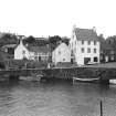
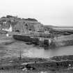
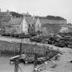
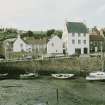
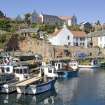
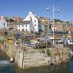
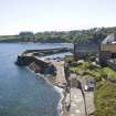
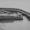
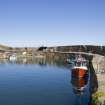
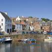
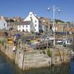
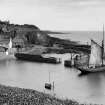
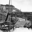
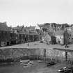
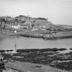
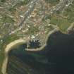
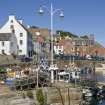
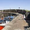
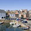
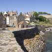
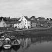
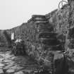
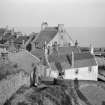
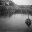
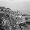
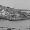
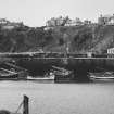
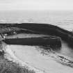
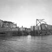
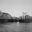
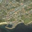
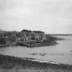
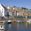
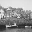
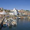
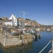
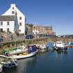
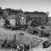
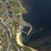
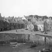
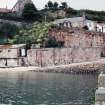
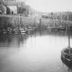
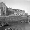
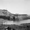
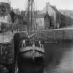
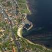
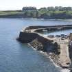
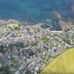
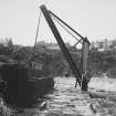
The site of the harbour is a small rocky pocket, enclosed on the E, SE and S by the curving breakwater-pier, and on the W by a straight pier running out towards the head of the latter but leaving an entrance in the SW corner of the harbour, and on the N and NE by quays based on dry land. The enclosed space measures about 180ft [54.9m] from N to S by 220ft [67.1m] transversely, and amounts to little more than 0.6acre [0.24ha]. The main pier measures about 375ft [114.3m] along its curve, with a further 100ft [30.5m] of sea-wall continuing its line to landward. Its outer face is rather irregularly aligned, and shows large rough blocks, partly dry-built and secured with wooden wedges and partly pointed with cement, standing on a heavily battered and mortared base. The internal face, below the walkway, is mainly of drystone masonry vertically set, although with a patch of irregularly coursed horizontal work about the centre. That the pier once had wooden fenders or protection of some sort is suggested by a record of 1788 to the effect that its timber was then very rotten, and with this may be compared allusions to 'coal walling', ie. presumably timbering along the face, in 1827 and 1829. The parapet varies in height from 5ft [1.5m] to 10ft [3m], and was 12ft [3.7m] thick on top where measured, although this dimension likewise varies. It is provided with five flights of steps, one of which descends its end at the pier-head and also gives access to the sea outside the pier, while the others are recessed laterally into its face. A sixth flight has been destroyed in some reconstruction of the parapet, and the existing ones seem to belong to a fairly recent phase. The walkway is 20ft [6.1m] wide at its inner end and 9ft [2.7m] wide at narrowest; it is paved with slabs and large unshaped stones, perhaps laid or relaid in 1879, is edged with uneven slabs, and carries eight rough stone pawls, three of which are set in stair-recesses and one in a recess of its own. The pier-head was rebuilt in 1871, but as booms had already been installed in 1854, some earlier reconstruction must presumably have been done to narrow the entrance suitably. It is now about 30ft [9.1m] wide, and has chases for booms which, with their crane, are present and in working order.
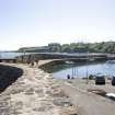
The West Pier originated in a plan for improvements prepared by Messrs Robert Stevenson and Sons in the early 1820's, and in 1825 an estimate for £1095 for building the pier and deepening the harbour was accepted from John Gosman, with whom Alexander Wishart seems to have been associated. A grant of £500 had been received from the Convention of Royal Burghs. The work, which was finished in 1828, is 130ft [39.6m] long by 16ft [4.9m] wide over a parapet 2ft 6ins [0.8m] thick and 4ft [1.2m] high; the parapet ends well short of the pier-head and is of a different build. The pier-head is clearly later than the rest of the work, and was no doubt added when the entrance was narrowed. Both faces of the pier show vertically set masonry, partly mortared, and smaller and neater than that of the main pier. The walkway is paved with setts, probably laid in 1866, and carries one large and four small stone pawls, two of them in recesses in the face of the parapet.
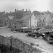
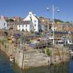
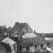
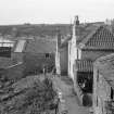
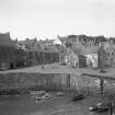
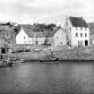
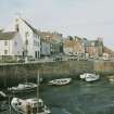
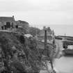
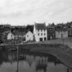
The quay on the N side of the basin carries a street [Shoregate] which forms the town's harbour frontage, and communicates, by means of a ramp at its W end [NO c. 61152 07413], with the sandy beach W of the West Pier [NO60NW 31.03]. This arrangement recalls the 'path for driving seaweed from the West Shore to the new pier' for which estimates were called in 1827. From the West Pier, the quay runs E for about 140ft [42.7m], and then turns SSE, sloping downwards for some 90ft [27.4m] along the face of the main pier, and thus filling up the NE corner of the original basin. Both sections of the quay are faced with vertically-set drystone masonry, apart from a patch, 42ft [12.8m] long, of well-coursed horizontal work, which has been inserted below the splayed-out end of the Shore gate [presumably at NO c. 61203 07415]. Three very large, rough stone pawls stand against the house-fronts in the W part of the quay, and two others, less rough, respectively in its E part and at the former N end of the pier walkway.
Two record items bear on the date of the quay in its present form. (i) As late as 1829 a long-standing condition was still attached to the annual roup of the Customs, by which ships were forbidden to fix their rope 'to the Upstanders or Barkels of the Pier, but upon the Poles'. This seems to imply that the quay-face at that time contained upright timbers, which could have been pulled out by vessels moored to them, and also that, to avoid this danger, mooring-posts were set up clear of the face, like bricole for gondolas outside a Venetian palace. (ii) In 1833, the construction was authorised of a facing-wall, in the form of a slip, which the contractor, David Gavine, subsequently stated to be 99ft [30.2m] by 13ft 4ins [12m] high. Though the language of the minute is not altogether clear, there can be little doubt that the structure of 1833 was the sloping E part of the quay, particularly in view of the close correspondence of their lengths. It is thus tempting to date the quay, in its present form, to the 1830's, and on that showing the distinctive patch below the Shoregate would fall into place as a repair of 1872, when a 40ft [12.2m] length of the N side of the harbour was taken down and rebuilt, being considered unsafe.
A ramp some 85ft [25.9m] long runs on from the foot of the down-sloping portion of the quay to the bottom of the harbour, still flanking the main pier's inner face. [This is presumably to be equated with the slipway NO60NW 31.05]. Comparison with the OS maps shows that this was built after 1856 but before 1912.
A Graham 1971.
(Location cited as NO 612 073). Crail Harbour, built 16th-19th centuries. A basin formed by two rubble piers. The main (east) pier dates from the 16th-18th centuries; the west pier from 1825-8, engineers Robert Stevenson and Sons. The enclosed shore was quayed in the 1830's.
J R Hume 1976.
A small tidal harbour, the most picturesque in the East Neuk, reached by the steep descent down Shoregate.
The hook-shaped East Pier came first. It was described in a typical series of applications to the Convention of Royal Burghs as 'new foundit' (1610) and 'old and ruinous, a great part of it beat down by a storme this last winter' (1707), and eventually received a grant of £20 towards repairs in 1728. Massive parapet on the outer side and recessed steps on the inner, which is largely of squared stones in vertical courses.
The straight West Pier was designed by Rovert Stevenson in 1821 and built by John Gosman in 1826-8 for £1095 with a grant of £500. Pierhead rebuilt in 1871.
J Gifford 1988.
Site recorded by Maritime Fife during the Coastal Assessment Survey for Historic Scotland, Kincardine to Fife Ness 1996.
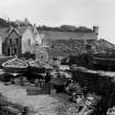
Photographic Survey (July 1960)
Photographic survey by the Scottish National Buildings Record in July 1960.
Publication Account (1987)
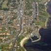
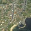
Crail was created a Royal Burgh in 1310 and is likely to have had some form of protecting bulwark from an early period. The date of the construction of the south quay of the existing harbour is uncertain but the vertically-jointed masonry suggests a late 15th or early 16th century structure. By 1593 the harbour was considered to be too small and a supplication was made to the Convention of Royal Burghs asking that an area of ground called 'Pinkertoun' be purchased for the founding and erecting of a harbour to the town. The position of this harbour to the east of the burgh would appear to be a large natural haven later referred to as Roome Harbour (NO 619078).
The petition was continued for many years but without success, the last attempt being in 1610 when the old harbour was in need of repair. Many of the harbours of Scotland were destroyed or badly damaged in the storms of the 1650s and, with trade and commerce at a low ebb, any development was unlikely. At the beginning of the 18th century Crail granted the sum of £20 sterling to repair the ruinous harbour. No further development took place until the early years of the 19th century. Ainslie's map for 1775 shows Crail harbour as comprising a single dog-leg quay. In 1821, Robert Stevenson produced a plan for the improvement of the old harbour. This work appears to have been carried out as Dower's map of 1828 suggests the building of the west quay which still survives.
With the return of herring to the Firth of Forth in the 1830s and 1840s, Crail again attempted to have a harbour built at Roome. James Leslie, the Dundee Harbour Board engineer, prepared a plan in 1846. This consisted of two proposals for an 'Asylum Harbour' in Roome Bay. The first plan enclosed an area of 6.48 hectares of water at low tide and 9.3 hectares between the low and high watermark. He also suggested a wet dock and repairing dock or slip between high and low water. The smaller plan was similar but with a reduced area of deep water. This proposal was prepared in the light of a Government plan to create a 'Harbour of Refuge' on the east coast of Scotland. Crail's claim for this harbour included lists of recent wrecks on the Carr Rocks. They also proposed that the Cellardyke fishermen could 'emigrate' to Crail. Wick in Caithness was, however, selected as the site for this harbour in 1858.
Crail abandoned the 'Roome' project and effected improvements to the old harbour. These were completed in January 1862 with the erection of a crane to place booms at the entrance. The 19th century work at the entrance to the harbour is very obvious as it is built with horizontal masonry and mortar joints. The boom was intended to protect boats in the harbour in stormy weather, but fishermen complained that it obstructed free access and egress for their boats.
There has been no further development since that period other than general repairs and the harbour is now used by only a few very small boats working lobster pots. It is an attractive place and does much to put the scale of medieval trading vessels in perspective.
Information from ‘Exploring Scotland’s Heritage: Fife and Tayside’, (1987).
Project (2007)
This project was undertaken to input site information listed in 'Civil engineering heritage: Scotland - Lowlands and Borders' by R Paxton and J Shipway, 2007.
Publication Account (2007)
A small harbour existed here from at least as early as the 16th century, since when in its early history it seems to have been so often ruinous and under repair that it is difficult to date the earliest features with any certainty. The earliest or eastern curved pier or breakwater enclosng the harbour on the seaward side is about 375 ft long. The straight west pier about 130 ft long was built from 1826 to 1828 to the design of Robert Stevenson. The estimate of contractor John Gosman of £1095 was accepted for building the pier and deepening the harbour. Since then, apart from some small extensions, repairs and improvements, the harbour is little changed.
Unusual engineering features are areas of vertically set dry-stone masonry offering greater resistance to wave
pressure probably dating from the 18th or early-19th centuries and, the use in the seaward face of the curved
pier of stone blocks, partly dry built and secured with wooden wedges to reduce wave force effects.
R Paxton and J Shipway 2007
Reproduced from 'Civil Engineering heritage: Scotland - Lowlands and Borders' with kind permission from Thomas Telford Publishers.

