
Pricing Change
New pricing for orders of material from this site will come into place shortly. Charges for supply of digital images, digitisation on demand, prints and licensing will be altered.
East Mains Of Aboyne


Linear Feature(S) (Period Unassigned), Palisaded Enclosure (Period Unassigned), Rig And Furrow (Medieval) - (Post Medieval)
Site Name East Mains Of Aboyne
Classification Linear Feature(S) (Period Unassigned), Palisaded Enclosure (Period Unassigned), Rig And Furrow (Medieval) - (Post Medieval)
Alternative Name(s) Aboyne; Aboyne Golf Course; 'timber House Site'; Heogan
Canmore ID 35303
Site Number NO59NW 33
NGR NO 53152 99109
Datum OSGB36 - NGR
Permalink http://canmore.org.uk/site/35303


- Council Aberdeenshire
- Parish Aboyne And Glentanar
- Former Region Grampian
- Former District Kincardine And Deeside
- Former County Aberdeenshire
NO59NW 33 532 992
?Native settlement, Aboyne. NO 532 992.
(Undated) information in CUCAP card index.
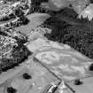
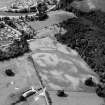
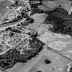
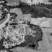
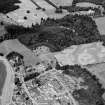
(Location cited as NO 5310 9910: nominated as Site of Regional Significance). Air photography has recorded the cropmarks of a timber house site on a gentle slope at an altitude of 125m OD. It is circular on plan and measures about 30m in diameter. A thin ring is enclosed by a thicker ring and post-holes are visible in the interior; the entrance was possibly on the E.
[Air photographic imagery listed].
NMRS, MS/712/35 and MS/712/36.
Classified as Heogan, palisaded enclosure... the remains of an enclosure and timber house of later prehistoric date, visible as cropmarks on oblique aerial photographs. The monument lies in arable farmland at an altitude of around 120m OD on the outskirts of Aboyne.
Information from Historic Scotland, scheduling document dated 29 October 2003.
Aerial Photographic Transcription (18 November 1999)
An aerial transcription was produced from oblique aerial photographs. Information from Historic Environment Scotland (BM) 31 March 2017.

