
Fort William, Golf Green


Golf Course (19th Century)
Site Name Fort William, Golf Green
Classification Golf Course (19th Century)
Canmore ID 352995
Site Number NN07SE 35
NGR NN 09682 73304
Datum OSGB36 - NGR
Permalink http://canmore.org.uk/site/352995


- Council Highland
- Parish Kilmallie
- Former Region Highland
- Former District Lochaber
- Former County Inverness-shire
Note (10 March 2016)
NN07SE 35
Fort William, Golf Green
Golf Course
NN 09682 73304
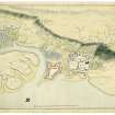
A Golf Green is depicted on a Board of Ordnance military map. Buildings of Fort William are shown on the current edition of the OS 1:10000 map. Information from HES Collections (RC) 10 March 2016.
Note (October 2017)
The map dissected
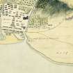
Within the archive of Historic Environment Scotland there is a rare military map of Fort William, commissioned by the Board of Ordnance and dating probably to the early 19th century. The buildings within the fort are annotated and a key describes the use of each structure: ‘new powder magazine’, ‘stable’ etc. The adjacent town is also shown in some detail, with houses, gardens and two burial grounds. In one respect the plan is particularly unusual for its type, as it depicts a Bowling Green to the north west of Fort William, and a Golf Green to the east.
Bowls can trace its Scottish origins back to the 15th century but it was not until the 18th century that it became an established sport, with several greens depicted on Edgar’s 1742 map of Edinburgh (Edinburgh World Heritage). There is no firm evidence for the origins of golf in Scotland but one suggestion is that medieval shepherds would hit stones into rabbit scrapes! Golf was apparently a popular pastime in St Andrews by the early 15th century and a century later, wealthy people played at courses in Edinburgh, Montrose and St Andrews. Documentary evidence exists for early golf sites in north east Scotland, such as Dornoch in 1616, but little suggests that people were golfing in the north west of Scotland until the late 19th century. This map of Fort William is therefore rare evidence which indicates that golf was being played during the era of the long-nosed wooden golf clubs and feathery golf ball.
The map also shows the busy village to the south east of the fort. Some 70 buildings are shown, including the Governor’s House that survives to this day. This old core of the burgh of Fort William is also depicted on the 1st edition of the 25” Ordnance Survey map (1876), by which time the concentration of the town had moved to the south, flanking a new main street, and the old town square had become ‘The Parade’. By this date both the golf and bowling areas were gone: a carding mill, Belford Hospital and the adjacent fields occupied part of the site of the latter and the former was subsumed into fields. Most of the other buildings shown on the plan had also been removed, but a new sporting arena was added – a curling pond.
The Board of Ordnance / Who used the Bowling and Golf Greens?
The Board of Ordnance was established in the 15th century and survived until it was disbanded in 1855. It was responsible for safeguarding the nation from threat, taking on tasks that included the production maps showing military roads, and plans of individual military structures.
The Jacobites posed a real danger to the Union in the 18th century, which led to the Board constructing and repairing several forts around Scotland where Government soldiers could be stationed. The fort at Fort William was begun in 1654 and rebuilt in 1746 by Dugal Campbell (Gifford 1992, 241-242). It was strategically positioned at the south west end of the Great Glen, completing a chain that included Forts Augustus and George.
The Bowling and greens were probably created for soldiers, most likely officers, who would have had the wish, time and money to play. Golf was still mainly a pursuit of the rich at this time since clubs and balls were expensive to buy and easy to damaged. However, it is possible that the recreation areas were used by local gentry, or bowling or golfing societies.
Golf was becoming a more widely spread sport by the 18th century with societies being instituted that played on new and established sites around Scotland. The depiction of Bowling and Golf Greens in such close proximity to a fort on this map is intriguing and offers a new insight to how these sports were viewed and played in the 18th century.
References:
Gifford, John (1992) The Buildings of Scotland: Highlands and Islands
Richard Craig - Archivist, Historic Environment Scotland

