
Cloch Point Battery


Building (First World War)
Site Name Cloch Point Battery
Classification Building (First World War)
Canmore ID 352775
Site Number NS27NW 21.33
NGR NS 20367 75610
Datum OSGB36 - NGR
Permalink http://canmore.org.uk/site/352775


- Council Inverclyde
- Parish Inverkip
- Former Region Strathclyde
- Former District Inverclyde
- Former County Renfrewshire
Field Visit (3 March 2016)
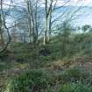
Situated some 50m west of and downslope from the Ex-DO post, and at the edge of a steep slope overlooking the Clyde at its narrowest point, is a rectangular platform that has been cut into the slope. Probably constructed to support a timber building, it measures 7m from N to S by 5m transversely within a rear scarp 0.9m in depth and a front apron 1.2m in height and containing a number of large stones. The north end of the platform, the outlook and position of which are suggestive of military activity, has been disturbed by fallen trees and vegetation.
Visited by HES Survey and Recording (AM, AK) 3 March 2016.

