
Cloch Point Battery


Machine Gun Post (First World War)(Possible), Sentry Post (First World War)(Possible)
Site Name Cloch Point Battery
Classification Machine Gun Post (First World War)(Possible), Sentry Post (First World War)(Possible)
Canmore ID 352767
Site Number NS27NW 21.30
NGR NS 20449 75621
Datum OSGB36 - NGR
Permalink http://canmore.org.uk/site/352767


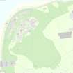
- Council Inverclyde
- Parish Inverkip
- Former Region Strathclyde
- Former District Inverclyde
- Former County Renfrewshire
Field Visit (2 March 2016)
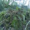
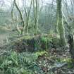
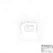
The remains of what may have been a sentry post or machine-gun post are situated in woodland some 20m NE of the fire command post, on a slope just above a terrace created by a field bank running WNW and ESE. The site comprises a platform which extends 4m out from the slope, is 5m in breadth and is a maximum of 0.75m in height along its front edge, at the centre of which is a grass-grown rectangular mound measuring 2m from NW to SE by 1.75 transversely and up to 1m in height. In the centre of the top of the mound there is a rectangular depression measuring 1m from NW to SE by 0.75m transversely and a maximum 0.2m in depth. The feature commands a position overlooking the coastline but it is situated outside the defensive line of barbed wire, of which several stobs remain in situ.
Visited by HES Survey & Recording (AM, AK) 3 March 2016.
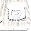
Measured Survey (3 March 2016)
HES surveyed the machine gun post (NS27NW 21.30) at Cloch Point Battery with plane-table and alidade on 3 March 2016 at a scale of 1:50. The resultant plan was redrawn in vector graphics software at a scale of 1:250.

