
Bridgend Of Lethnot


Ring Cairn (Neolithic) - (Bronze Age), Stone Circle (Neolithic) - (Bronze Age)(Possible)
Site Name Bridgend Of Lethnot
Classification Ring Cairn (Neolithic) - (Bronze Age), Stone Circle (Neolithic) - (Bronze Age)(Possible)
Canmore ID 35004
Site Number NO56NW 14
NGR NO 5360 6818
Datum OSGB36 - NGR
Permalink http://canmore.org.uk/site/35004


- Council Angus
- Parish Lethnot And Navar
- Former Region Tayside
- Former District Angus
- Former County Angus
NO56NW 14 5360 6818.
(NO 5359 6818) Cairn (NR)
OS 1:10,000 map, (1974).
A small cairn situated on the edge of a spur and composed wholly of small stones now overgrown with grass and gorse. It measures 9.2m in diameter and 1.0m in height, and is bounded by a kerb of large stones, some of which are erect, the highest being 0.7m. A slight hollow in its centre probably denotes an early excavation. A number of small stones lie scattered around the site. (Name Book c 1861).
Visited by OS(JLD) 16 July 1958.
A cairn, as described.
Resurveyed at 1:2500.
Visited by OS(RL) 7 November 1967.
Note (1983)
Bridgend NO 535 681 NO56NW 14
Situated on the edge of a spur there is a cairn measuring 9.2m in diameter over a boulder kerb and 1m in height.
RCAHMS 1983
(Name Book, Forfar, No. 60, p. 72).
Field Visit (14 September 1989)
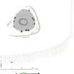
What are probably the remains of a ring-cairn with a surrounding stone circle, formerly identified simply as a burial-cairn, are situated on a promontory 400m NE of Blairno. The ring-cairn measures about 9.5m in overall diameter by 0.5m in maximum height and there is a shallow depression at its centre. No inner kerbstones are visible, but at least five outer kerbstones survive in situ, all on the S and W arcs, and numerous others lie displaced around the edge of the cairn. The four largest kerbstones probably formed a setting on the SSW side of the cairn; originally this setting comprised two slabs set in a line immediately back from two flanking blocks (about 0.7m high), but one of the slabs (1.5m by 1.2m) has been pulled forwards out of position. All that is visible of the surrounding stone circle is a leaning slab 0.75m high on the NE, and a recumbent slab 1.5m long on the SE.
Visited by RCAHMS (SH) 14 September 1989.
Field Visit (21 June 2005)
Lying within improved pasture at the E end of a promontory, this cairn was once surrounded by a stone circle. Now largely grass-grown, it survives as a flat-topped mound measuring 10.5m in diameter, and ranging in height from 0.45m on the S and E to 1m on the N. Kerbstones define its outer edge, three of which survive in situ on the W, a further possible three on the E, and a setting incorporating another three on the SSW. The latter are the largest stones, suggesting that the kerb may have been graded in height towards the SW. The setting originally comprised two blocks standing in front of and to either side of two slabs on the line of the kerb, though only one of these now survives. A second slab, forming its partner, was displaced forward of the kerb in 1986 but has since been removed. Within the body of the cairn, there is an oval hollow measuring 4.2m from E to W by 3.3m transversely and 0.3m in depth, but in the absence of any kerbstones it is impossible to say whether this marks an internal court or is simply the result of stone robbing. Only two stones of the surrounding stone circle can still be seen, and of these only that on the NE stands in situ, the other lying flat on the SE. A plough scar is visible around the cairn on the S and E.
Visited by RCAHMS (ATW,ARG) 21 June 2005
Measured Survey (21 June 2005)
RCAHMS surveyed Bridgend of Lethnot ring-cairn on 21 June 2005 with plane table and alidade producing a plan and section at a scale of 1:100. The survey drawing was later used as the basis for an illustration redrawn in vector graphics software at a scale of 1:250.

