
Begbie Wood


Ring Ditch (Period Unassigned)(Possible)
Site Name Begbie Wood
Classification Ring Ditch (Period Unassigned)(Possible)
Canmore ID 349745
Site Number NT47SE 67
NGR NT 49669 70094
Datum OSGB36 - NGR
Permalink http://canmore.org.uk/site/349745


- Council East Lothian
- Parish Haddington
- Former Region Lothian
- Former District East Lothian
- Former County East Lothian
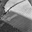
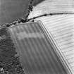
Aerial Photography (21 July 1995)
This possible ring ditch is situated on a slight ridge to the W of Begbie Wood and has been recorded as cropmarking on oblique aerial photographs (RCAHMSAP 1995). It measures about 7m in diameter within a ditch about 1.5m across.
Information from HES, Survey and Recording (DCC) 25 January 2016

