
Marcus


Temporary Camp (Roman)
Site Name Marcus
Classification Temporary Camp (Roman)
Canmore ID 34819
Site Number NO55NW 37
NGR NO 5110 5800
NGR Description Centred NO 5110 5800
Datum OSGB36 - NGR
Permalink http://canmore.org.uk/site/34819


- Council Angus
- Parish Tannadice
- Former Region Tayside
- Former District Angus
- Former County Angus
NO55NW 37 centred 5110 5800.
A section cut across the ditch at NO 5125 5830 at the E end of the camp, showed the ditch to be U-shaped 1.30m wide surviving to a depth of 0.8m below the surface of the plough soil.
J R Sherriff 1982.
Two trenches cut through the distinct cropmark known as Marcus 63 acre camp, revealed a well preserved, V shaped ditch some 2m deep. A third cutting investigated the titulum gate feature which has also survived well. A single cutting was placed across the Finavon Camp cropmark, but in this case the survival was poor, due to gravel extraction in the area in the 1970's.
E Halpin 1987.
Excavation located the titulum ditch at the more westerly gateway on the N side of this 63-acre camp. It was 3.4m wide and 1.4m deep. The main ditch of the camp had been removed by quarrying, but a low bank c.10m wide and 0.35m high running across the cottage garden c.15m behind the titulum was taken to represent the rampart. The W ditch of the camp was sectioned close to the A49 road and was found to be 3.15m wide and 1.2m deep below 0.6m of topsoil.
S S Frere 1988.
Note (1983)
Marcus, Temporary Camp NO 511 580 NO55NW 37
This temporary camp, which has been associated with the campaigns of the emperor Septimius Severus (c. AD 208-11), is situated on a level terrace on the left bank of the River South Esk immediately to the N of Marcus House. Roughly trapezoidal on plan, it measures some 61Om from NE to SW by at least 400m transversely (c. 25ha), and, an annexe some 1.1 ha in area is attached to its SW side. A short portion of the NE side, possibly including a gate, is preserved as a shallow ditch in a plantation on the S side of the A94 at 513 582. The positions of three other gates, each defended by a titulum have been revealed by cropmarkings.
RCAHMS 1983.
(St Joseph 1969, 111).
Publication Account (17 December 2011)
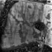
The camp at Marcus was first discovered as a cropmark from the air by St Joseph in 1967 (1969: 111), lying on undulating ground to the north of the River South Esk. Just below the south side of the camp the land drops away sharply to the river. The camp at Finavon lies 1km to the WSW.
St Joseph noted that the south side of the camp had been eroded by the river (1969: 111). A linear cropmark is visible on air photographs taken in 1977, but this does not appear to represent the south side of the camp, which is probably closer to the edge of the plateau. The camp measures around 635m from south-west to north-east by about 400m transversely, enclosing an area of some 24.6ha (61 acres). There is a small annexe attached to the south part of the south-west side, measuring 112m by 110m, which encloses an additional 1.11ha (2.7 acres) and has a titulus in the centre of its south-west side.
An entrance gap is visible in the centre of the southwest side, protected by a titulus, and two more are visible, also protected by tituli, in the north-west side. There is an earthwork in the small plantation on the east side, to the south of the A90(T) (formerly the A94), which may represent the denuded remains of the rampart on this side, although rig and furrow also survives in the plantation which is almost parallel to this earthwork. It is only about 15m in length, is spread about 6m in width and is up to 0.5m in height. There are the traces of a low depression, possibly a ditch, on the east side of the rampart. The plantation lies on ground above the surrounding fields, possibly indicating the level of truncation of the site by the plough. Excavations in 1982 on the northern part of the northeast side recorded a U-shaped ditch which was 1.3m wide, surviving to a depth of 0.8m below the surface of the plough soil (Sherriff 1982: 31; information in the RCAHMS). Later excavations in 1987 recorded that the ditch on the north side was about 3.15m in width and 1.2m in depth. The ditch of the west titulus on the north side was V-shaped, measuring about 3.4m in width and 1.4m in depth (Halpin 1992: 177–8). Halpin also observed a low bank to the west of the excavated titulus by Marcus Cottage, 15m south of the titulus ditch, measuring about 18m in length, 10m in width and 0.35m in height. The implication is that this bank could also represent the denuded remains of part of the rampart of the camp (Halpin 1992). It therefore appears likely that two small stretches of the rampart of this camp have survived.
R H Jones.

