
The Chesters


Ring Ditch House(S) (Later Prehistoric)
Site Name The Chesters
Classification Ring Ditch House(S) (Later Prehistoric)
Alternative Name(s) Foster Law
Canmore ID 347999
Site Number NT57NW 189
NGR NT 51116 78541
Datum OSGB36 - NGR
Permalink http://canmore.org.uk/site/347999


- Council East Lothian
- Parish Athelstaneford
- Former Region Lothian
- Former District East Lothian
- Former County East Lothian
Note (26 September 2022)
The location, classification and period of this site have been reviewed.
Aerial Photographic Interpretation (29 September 2022)
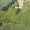
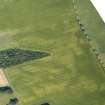
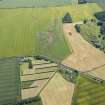
Two later prehistoric ring ditch houses have been recorded as cropmarking on oblique aerial photographs (RCAHMSAP 2015) on level ground around 360m NE of The Chesters fort (NT57NW 1). The first (NT 51114 78540) is visible as a crescent-shaped cropmark forming the S section of a ring ditch house measuring about 12m in diameter over a ring ditch about 3m broad. The second ring ditch house (NT 51208 78532) lies some 80m E. It is also visible as a crescent-shaped cropmark and measures about 11m in diameter.
Information from HES Archaeological Survey (F. Vermeij) 29 September 2022

