
Craigneich


Standing Stone (Prehistoric)
Site Name Craigneich
Classification Standing Stone (Prehistoric)
Canmore ID 345784
Site Number NN71NE 1.01
NGR NN 7922 1787
Datum OSGB36 - NGR
Permalink http://canmore.org.uk/site/345784

- Council Perth And Kinross
- Parish Muthill
- Former Region Tayside
- Former District Perth And Kinross
- Former County Perthshire
Field Visit (19 August 1942)
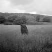
'Standing Stone', Craigneich.
A block of triangulat section 6'3" x 4'3" on NW face x 2'3" thick to [aris] - on a valley just over the 500' contour now planted with corn. At base there is an excrescence 1'2" thick from S face. Close to Muthill road.
Visited by RCAHMS (VGC) 19 August 1942.

