
Carlungie


Souterrain (Prehistoric)
Site Name Carlungie
Classification Souterrain (Prehistoric)
Alternative Name(s) Carlungie Ii
Canmore ID 34546
Site Number NO53NW 24
NGR NO 5100 3584
Datum OSGB36 - NGR
Permalink http://canmore.org.uk/site/34546


- Council Angus
- Parish Monikie
- Former Region Tayside
- Former District Angus
- Former County Angus
NO53NW 24 5100 3584.
(NO 5100 3584) Souterrain (NR) (site of) (NAT)
OS 6" map (1969)
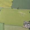
A souterrain (Carlungie II) discovered on 7 November 1949 in the same field as Carlungie I (NO53NW 14). It was partially excavated by Wainwright on 27-28 March 1951 and thereafter covered up so that there is no surface indication of the site.
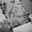
The limited excavation did not establish the length of the passage, but its width, height, corbelled walls and other structural features show that in general character it resembles Carlungie I (NO53NW 14) and Ardestie (NO53SW 1). In the filling of the passage were found part of a rotary quern and a Gaulish bronze brooch, cruciform with glass and enamel inserts, which is listed as Roman by Miss Robertson, and dated to not earlier than the 2nd century AD.
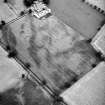
Surface structures were not located by the excavation but were suggested by the fact that the finds came from the filling.
F T Wainwright 1963; A S Robertson 1970
NO 5135/5136 and NO 5034 A copper alloy ball with a hole pierced in one end, 3.5cm in diameter, was discovered in the vicinity of a souterrain in the Carlungie/Ardestie area, as a surface find. It was brought in as a verbal enquiry to Montrose Museum in 1994 and to Glasgow Museums in January 1995. It was retained by the finder. Glasgow Museums Enquiry Number 1306.
R Benvie 1995
Excavation (27 March 1951 - 28 March 1951)
A souterrain (Carlungie II) discovered on 7 November 1949 in the same field as Carlungie I (NO53NW 14). It was partially excavated by Wainwright on 27-28 March 1951 and thereafter covered up so that there is no surface indication of the site.
The limited excavation did not establish the length of the passage, but its width, height, corbelled walls and other structural features show that in general character it resembles Carlungie I (NO53NW 14) and Ardestie (NO53SW 1). In the filling of the passage were found part of a rotary quern and a Gaulish bronze brooch, cruciform with glass and enamel inserts, which is listed as Roman by Miss Robertson, and dated to not earlier than the 2nd century AD.
Surface structures were not located by the excavation but were suggested by the fact that the finds came from the filling.
F T Wainwright 1963; A S Robertson 1970

