
Long Nose


Promontory Fort (Period Unassigned)
Site Name Long Nose
Classification Promontory Fort (Period Unassigned)
Alternative Name(s) Wanford Burn
Canmore ID 344995
Site Number NJ86SW 66
NGR NJ 82590 63104
Datum OSGB36 - NGR
Permalink http://canmore.org.uk/site/344995


- Council Aberdeenshire
- Parish Gamrie
- Former Region Grampian
- Former District Banff And Buchan
- Former County Banffshire
Note (29 April 2015 - 4 August 2016)
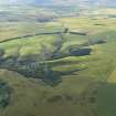
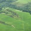
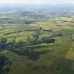
Cropmarks have revealed the ditches of what is probably a fort occupying the promontory known as Long Nose, which is formed between deep gullies of burns flowing into the Tore of Troup from the W. The crest of the promontory appears to rise gently into a summit at its ESE end from a ditch about 8m in breadth cutting transversely across the neck. Bleached stripes in the crop extending across the neck outside it suggest the presence of possibly as many as three ramparts, though the ditches between them are not particularly clearly defined. The interior, which measures 95m from ESE to WNW by 45m transversely (0.4ha), is featureless and the position of the entrance is not known. In addition to the inner defences there are possible traces of a ditch 4m in breadth with an external rampart at the very root of the promontory some 95m WNW of the inner ditch; this bars access to an overall area measuring 205m in length (0.92ha).
Information from An Atlas of Hillforts of Great Britain and Ireland – 04 August 2016. Atlas of Hillforts SC2985

