
Sanday, Stove, Old Steading


Farmstead (19th Century) (1852)-(1862)
Site Name Sanday, Stove, Old Steading
Classification Farmstead (19th Century) (1852)-(1862)
Alternative Name(s) Stove, Old Steading
Canmore ID 3446
Site Number HY63NW 39
NGR HY 60881 35521
NGR Description Centred HY 60881 35521
Datum OSGB36 - NGR
Permalink http://canmore.org.uk/site/3446


- Council Orkney Islands
- Parish Cross And Burness
- Former Region Orkney Islands Area
- Former District Orkney
- Former County Orkney
HY63NW 39.00 60881 35521.
HY63NW 39.01 60900 35543 Farmhouse.
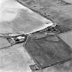
HY63NW 39.02 60768 35352 Farm cottages (Hill Street).
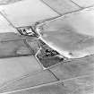
HY63NW 39.03 61119 35528 New steading.
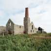
HY63NW 39.04 60866 35530 Threshing machine
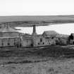
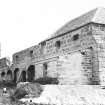
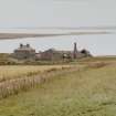
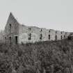
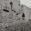
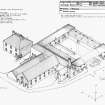
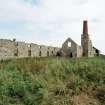
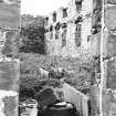
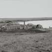
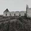
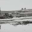
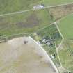
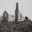
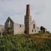
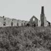
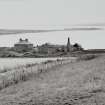
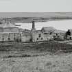
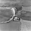
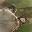
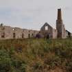
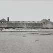
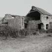
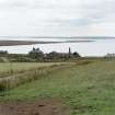
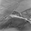
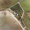
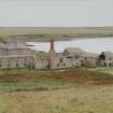
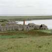
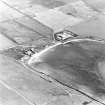
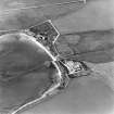
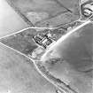
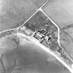
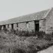
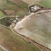
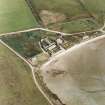
This steading is large, with an open rectangular plan, incorporating a steam-powered threshing barn and projecting byre with granary. The byre is double-stalled, with a central feed passage. There is a substantial farmhouse, workers' houses and outbuildings. A cattle shed with silage shed were appended in the late 1970s. The steading was divided into eight lots in the early 1920s and the complex was seriously damaged in a fire in the early 1970s. The buildings were largely disused and roofless on the date of visit.
Visited by RCAHMS (GJD), September 1996; NMRS MS 500/36/73 (Scottish Farm Buildings Survey).
RCAHMS and NMS 1998b.
Large model farm, one of the first to introduce mechanisation to the Islands in the form of a steam driven threshing machine.
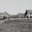
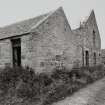
A pair of single storey cottages sit to the east of the main farmhouse, with centred lean-to porches flanked by boarded doors to the left and right. The west cottage features a window to the centre, whilst the east cottage features a window to the outer left. The south elevation of each cottage features a central blocked doorway flanked by windows. Roofs are in graded stone tile, whilst windows are timber framed.
The row of 6 cottages to the south west are similar in build, though the southernmost 2 are now roofless.
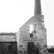
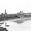
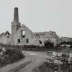
In general, the ancillary ranges are now ruinous, but continue to form large courts, and some retain their roofs. The red brick chimney of the boiler house survives as a prominent landmark to the north west.
Field Visit (July 1979)
A large and very noticeable complex of farm buildings,
formerly the centre of a 1000-acre estate now owned by Dept of
Agriculture and let to several tenants in smaller units. Some of
the buildings, arranged around a large courtyard, are still in
use. Notable among the ruined ones are an enormous byre with
rows of stone stall-slabs, and the engine house and chimney
(square and stone-built in its lower part, round and red-brick
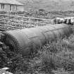
above) which served a mill. The boiler is still lying beside the
track near the engine-house. This complex represents an early
example, unusual in Orkney, of a highly capitalised,
industrialised farming enterprise.
Information from Orkney SMR (RGL) Jul 79, cf OR 401.
Note (1980)
Stove, Sanday HY 6088 3552 HY63NW
Large and remarkable farm-building complex representing an early example, unusual in Orkney, of highly capitalised and industrialised estate-farming. Especially noteworthy are the enormous, ruined byre and the red-brick chimney which served a steam-driven mill.
RCAHMS 1980
(OR 400)
Field Visit (1999)
The farm at Stove, now largely ruinous, represents an unusually well-appointed steading. Dating from the 1860's, it mechanised early and was provided with a steam-powered threshing machine, of which the stump of the boiler chimney remains. The substantial farmhouse remains in use and some modern outbuildings have been added. A row of farmworkers cottages stand to the rear of the farmstead, in ruins. Ref.: RCAHMS (1980), #202; RCAHMS & NMS (1998) 'Scottish Farm Buildings Survey: Orkney', #37.
Coastal Zone Assessment Survey, 1999

