
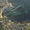
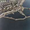
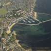
Anstruther Easter Harbour


Harbour (19th Century)
Site Name Anstruther Easter Harbour
Classification Harbour (19th Century)
Alternative Name(s) Anstruther Harbour; Shore Street; East Shore; Harbour Head; Firth Of Forth; Outer Forth Estuary
Canmore ID 34181
Site Number NO50SE 48
NGR NO 56831 03411
NGR Description Centred NO 56831 03411
Datum OSGB36 - NGR
Permalink http://canmore.org.uk/site/34181


- Council Fife
- Parish Anstruther Easter
- Former Region Fife
- Former District North East Fife
- Former County Fife
NO50SE 48.00 centred 56831 03411
Harbour [NAT]
OS 1:10,000 map, 1973.
NO50SE 48.01 NO 567 035 Hand crane
NO50SE 48.02 NO 5684 0343 Pier, crane
NO50SE 48.03 NO 56854 03429 Lifeboat House
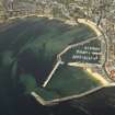
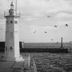
NO50SE 48.04 NO 56875 03224 West Breakwater, Chalmers Lighthouse (Anstruther Easter 1)
NO50SE 48.05 NO 56884 03224 West Breakwater, beacon
NO50SE 48.06 NO 56898 03176 East Breakwater, beacon (Anstruther Easter 2)
NO50SE 48.07 NO 56964 03437 East Breakwater, beacon (Anstruther Easter 3)
NO50SE 48.08 NO 56977 03474 East Breakwater, beacon (East Shore)
NO50SE 48.09 NO 56698 03551 Harbour Office
NO50SE 48.10 NO 56720 03542 Slipway
NO50SE 48.11 NO 56779 03482 West Pier
NO50SE 48.12 NO 56800 03349 to NO c. 56840 03418 Middle Pier
NO50SE 48.13 NO 56741 03454 Inner (NW) Basin
NO50SE 48.14 NO 56892 03322 Outer (SE) Basin
NO50SE 48.15 NO 56843 03420 Old Lifeboat House
For (adjacent to N) Scottish Fisheries Museum (St Ayles, Harbour Head), see NO50SE 21.00.
For Cellardyke Harbour (centred NO 57725 03844), see NO50SE 47.
For Anstruther Wester harbour (NO 565 035) at the mouth of the Dreel Burn, see NO50SE 49.
For (adjacent to N) former Smith and Hutton boatbuilding yard (Harbour Head), see NO50SE 61.00.
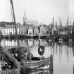
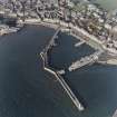
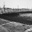
The 13th-century mention of the mouth of the Dreel Burn no doubt applies to whatever settlements then existed to the E and W of it, but apart from this no record of Easter Anstruther seems to be available before the 16th century. The by had no doubt long been in use as an achorage but harbour-works may not have originated until after, perhaps shortly after 1541, when Anstruther (NO50SE 55) and Pittenweem (NO50SW 58) were both created burghs with the right to build harbours 'unum seu plures'. Anstruther's harbour was certainly in existence by the 1580's when two prates 'war hangit on our Pier end' (1587) and a ship of the Spanish Armada arrived 'within our herbrie' (1588). A 'bulwark, peir, schoir and heaven' are mentioned in 1601, and it is said in the same passage that the 'bulwark', probably a breakwater with a quay, here called the 'peir', on its inner side, was 'weill and sunstantiouslie biggit' before it suffered damage in the storm and its 'remanent [was] schaikin lous'. There is probably no significance in the representation on Blaeu's map of East Fife (1654) of an L-shaped palisade in front of the town, as Gordon's map (1642) marks an ordinary pier and basin, and Blaeu himself shows a pier, and not the palisade, on the his general map of Fife. In 1703 there was a 'long, high and well-built Peer of Stone', which seems to have run out straight for some 540ft (164.6m) and then to have returned towards the W for a further 120ft (36.6m). This work is now incorporated in the existing central pier, but its original features and the traces of periodical repair are all obscured by cement. It can hardly have done more than provide some limited shelter to the Shore Street frontage of the port.
A great improvement was effected in 1753 by the construction of a second pier NW of the original one, so as to form, with it, a basin described in 1837 as 'commodious and safe'. This phase is illustrated by the 6-inch OS map that was surveyed in 1854. Originally about 550 ft (167.6m) long, the new pier was later extended to a total length of 1350 ft (411.6m), and another, some 960 ft (292.7m) long, was built between 1866 and 1877 to the E of the original pier, forming an outer basin with its entrance in the S corner. Today the harbour thus consists of two basins, echeloned NW and SE and separated by the original pier, this latter having been truncated by the cutting through of its seaward portion to provide access from the outer to the inner basib in place of the direct entry that was closed by the extension of the W pier across it. The returned head of the original pier, cut off in this way, has been incorporated into the extension of the W pier. Traces of these alterations appear very clearly on the outer side of the W pier, though most of the inner side is again masked by cement. The landward part of this work (1753) is of dry-stone blocks, but the innermost 90 ft (27.4m), like the adjoining revetment of the frontage roadway, is of large blocks with mortar, probably as a result of reconstruction. The alignment of the pier is rather irregular, and its face slightly battered. Beyond the angle, some 550 ft (167.7m) out, a short mortared stretch no doubt represents a repair; this is followed by 160 ft (48.8m) of neat, rusticated work, evidently part of the 19th century reconstruction, and this in turn connects with a stretch of rough and irregular work, clearly the detached and partially rebuilt head of the original pier. The rest of the W pier is all of the 19th century.
A Graham 1971.
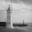
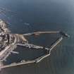
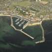
(Location cited as NO 568 034). Anstruther Easter harbour, rebuilt 1866-77 and subsequently partly rebuilt, notably in 1937. A single large basin, formed by a curved breakwater and an L-plan pier, divided into two by a two short straight piers. Much of the works are in reinforced concrete but there is sonme rubble masonry. At the seaward end of the breakwater is a neat octagonal concrete light-tower (NO50SE 48.05), and on the L-plan pier is a tapering cast-iron light-tower (NO50SE 48.04).
J R Hume 1976.
Site recorded by Maritime Fife during the Coastal Assessment Survey for Historic Scotland, Kincardine to Fife Ness 1996.
Project (2007)
This project was undertaken to input site information listed in 'Civil engineering heritage: Scotland - Lowlands and Borders' by R Paxton and J Shipway, 2007.
Publication Account (2007)
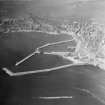
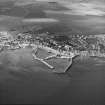
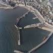
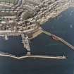
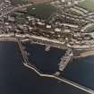
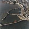
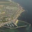
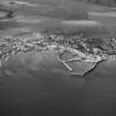
This harbour now consists of two basins separated by the central old pier which existed in 1703 having been developed from the 16th century. This pier then ran straight out from the shore for about 540 ft and then turned west for about 100 ft. Its original features and old repairs are now obscured.The harbour was much improved in 1753 with the construction of the west pier, of dry (unmortared) stone blocks, stopping short of the return of the central pier to leave an entrance to the newly formed western basin.
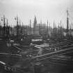
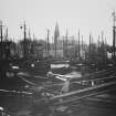
Between 1866 and 1877 the outer basin or Union Harbour was created. It comprised an east pier about 960 ft long andthe state-of-the-art western breakwater (with Chalmers Lighthouse) about 470 ft long joining the old central pier. A new entrance to the inner basin was cut through the central pier and the old entrance filled up to give a total length of western pier and breakwater of about 1400 ft. The engineers for this major deep-water improvement, which cost more than £80 000, were D. & T. Stevenson. In 1868 the young Robert Louis Stevenson gained experience on this work as part of his reluctant civil engineering training with the family firm. He watched the masons at work on the Fifeness stone ‘for 6d an hour’ drew the ‘travellers and Jennies’ used for transporting the stone blocks along the pier and into position laterally, and ‘loved the green glimmer of the divers helmets far below’.
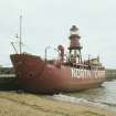
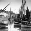
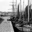
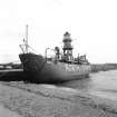
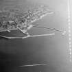
The ship at the east pier in the view is the North Carr Lightship after decommissioning in 1975.
R Paxton and J Shipway 2007
Reproduced from 'Civil Engineering heritage: Scotland - Lowlands and Borders' with kind permission from Thomas Telford Publishers.

