|
Manuscripts |
MS 515/4 |
Records of North of Scotland Archaeological Services, Orkney, Scotland |
Correspondence for Liddel & Beaquoy (3 volumes). |
1974 |
Item Level |
|
|
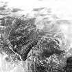
Photographs and Off-line Digital Images |
D 28612 |
RCAHMS Aerial Photography |
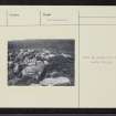
Oblique aerial view of Hill of Milton centred on the remains of a cairn, farmstead and rig, taken from the S. |
13/3/1998 |
Item Level |
|
|
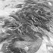
Photographs and Off-line Digital Images |
D 28613 |
RCAHMS Aerial Photography |
Oblique aerial view of Hill of Milton centred on the remains of a cairn, farmstead and rig, taken from the SE. |
13/3/1998 |
Item Level |
|
|
Photographs and Off-line Digital Images |
D 28614 |
RCAHMS Aerial Photography |
Oblique aerial view of Hill of Milton centred on the remains of a cairn, farmstead and rig, taken from the ENE. |
13/3/1998 |
Item Level |
|
 |
On-line Digital Images |
SC 1718686 |
RCAHMS Aerial Photography |
Oblique aerial view of Hill of Milton centred on the remains of a cairn, farmstead and rig, taken from the S. |
13/3/1998 |
Item Level |
|
 |
On-line Digital Images |
SC 1718687 |
RCAHMS Aerial Photography |
Oblique aerial view of Hill of Milton centred on the remains of a cairn, farmstead and rig, taken from the SE. |
13/3/1998 |
Item Level |
|
 |
On-line Digital Images |
SC 1718688 |
RCAHMS Aerial Photography |
Oblique aerial view of Hill of Milton centred on the remains of a cairn, farmstead and rig, taken from the ENE. |
13/3/1998 |
Item Level |
|
 |
On-line Digital Images |
SC 2407238 |
Records of the Ordnance Survey, Southampton, Hampshire, England |
Hill Of Milton, NO48SE 2, Ordnance Survey index card, Recto |
1958 |
Item Level |
|
 |
On-line Digital Images |
SC 2407239 |
Records of the Ordnance Survey, Southampton, Hampshire, England |
Hill Of Milton, NO48SE 2, Ordnance Survey index card, Recto |
1958 |
Item Level |
|
 |
On-line Digital Images |
SC 2407240 |
Records of the Ordnance Survey, Southampton, Hampshire, England |
Hill Of Milton, NO48SE 2, Ordnance Survey index card, Recto |
1958 |
Item Level |
|
|
All Other |
551 166/1/1 |
Records of the Ordnance Survey, Southampton, Hampshire, England |
Archaeological site card index ('495' cards) |
1947 |
Sub-Group Level |
|


