
Vayne Castle


Castle (16th Century)
Site Name Vayne Castle
Classification Castle (16th Century)
Canmore ID 33664
Site Number NO45NE 1
NGR NO 49346 59926
Datum OSGB36 - NGR
Permalink http://canmore.org.uk/site/33664


- Council Angus
- Parish Fern
- Former Region Tayside
- Former District Angus
- Former County Angus
NO45NE 1 49346 59926.
(NO 4936 5993) Dayne Castle (NR) (mis-spelling)
OS 6" map, (1959)
Vayne Castle (NR)
OS 6" map, Forfarshire and Angus, 2nd ed., (1927)
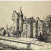
Vayne Castle: The ruin of a 16th century Z-plan castle with one round and one square tower. A stair turret is inserted in the re-entrant angle of the NE tower with the E side of the main block.
The castle, now ruinous, having been used as a quarry for the building of the farmhouse, was built by the Lindsays, who acquired the barony of Vayne or Fearn in the early part of the 15th century.
D MacGibbon and T Ross 1887-92.
Vayne Castle is now ruinous, the western part in particular being in very poor condition. The walls, c.1.5m thick, of the eastern part are almost entire.
Visited by OS (JLD) 9 July 1958.
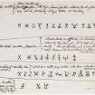
Antiquarian Observation (1857 - 1861)
Mason's marks from Scottish churches, abbeys and castles recorded between 1857 and 1861 on 29 drawings in the Society of Antiquaries of Scotland Collection.
Note (1984)
Vayne Castle NO 493 599 NO45NE 1
This castle, now ruinous, was erected on the Z-plan, probably in the second half of the 16th century, with a rectangular main block, a square tower at the NE angle and a circular tower at the SW angle.
RCAHMS 1984.
(MacGibbon and Ross 1887-92, iv, 55-8).

