
Kincreich Mill


Grain Drier (Period Unassigned), Grain Mill (Period Unassigned), Mill (Period Unassigned)
Site Name Kincreich Mill
Classification Grain Drier (Period Unassigned), Grain Mill (Period Unassigned), Mill (Period Unassigned)
Alternative Name(s) Kerbet Water; Invereighty; Mill Of Kincreich
Canmore ID 33662
Site Number NO44SW 9
NGR NO 44220 44960
NGR Description Centred NO 44220 44960
Datum OSGB36 - NGR
Permalink http://canmore.org.uk/site/33662


- Council Angus
- Parish Inverarity
- Former Region Tayside
- Former District Angus
- Former County Angus
Reference (24 August 2008 - 15 October 2009)
Review of historic maps,photographs, archives and printed sources
Field Visit (20 September 2009 - 18 March 2010)
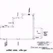
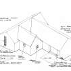
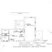
Measured survey and photographs
Srp Note (30 March 2011)
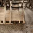
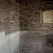
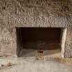
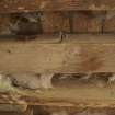
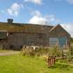
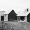
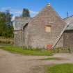
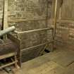
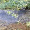
Kincreich Mill was a large grain mill lying on the SW bank of the Kerbet Water, occupying a site immediately S of the farm of the same name. It ceased operating, c1915/16, and its milling machinery was removed to an unknown mill in Fife during the 1940s. Today the building is used as a grain drying and storage facility for the farm.
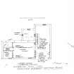
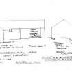
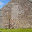
The mill is an L-shaped, pink sandstone building, aligned approximately NW/SE along its long axis, and comprises three distinct, though joined, units: a rectangular building to the S, aligned NW/SE (originally the mill, but now housing grain drying equipment; a second rectangular building to the N, set at right angles to the first (possibly a later addition, now used as a grain store); and a smaller, square building built into the right angle between the two long arms (possibly a later addition, built as a drying kiln, but now used as a grain silo). All of the buildings appear to have originally had a first floor and attic, but some of the floors have been removed since the mill ceased to operate, presumably increasing the storage capacity of the building in its present guise. There are several blocked door and window openings to both internal and external walls, and two large sliding metal doors have been inserted in the NE gable wall of the N building and in the SW wall of the S building. The mill lade was fed from a dam on the Kerbet Water, c 500m upstream (SW); it is still clearly evident, but has been blocked at the river dam and close to the mill building.
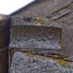
The records of the Abbey at Cupar Angus refer to a grain mill at Kincreich from the early thirteenth century, and an associated fulling mill at neighbouring Grange Mill from the sixteenth century. Later historical sources show an unbroken line of millers and farm tenants from the seventeenth century until 1915/16, when the grain mill appears to have ceased milling. A date stone set into the W corner of the N section of the building bears the date 1630 on its S face and 1750 on its W face. The present building is unlikely to be contemporary with either of these dates, but the stone may have been re-used from earlier mills on the site.
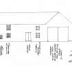
The mill was surveyed by Kinnettles and District Heritage Group, 2008 – 2010, and a survey report, plans and photographs are attached. For further information about the mill’s history, also see the attached 'Kincreich Mill Timeline', 'Kincreich Mill: extracts from Charters of the Abbey at Cupar Angus', and 'Kincreich Mill: extracts from Charters of the Abbey at Cupar Angus mentioning David Ruffus'.
Information from SRP Strathkerbet Grain Mills, February 2011.

