
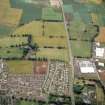
Westfield


Enclosure (Prehistoric)
Site Name Westfield
Classification Enclosure (Prehistoric)
Canmore ID 33582
Site Number NO44NW 12
NGR NO 44354 49540
Datum OSGB36 - NGR
Permalink http://canmore.org.uk/site/33582


- Council Angus
- Parish Forfar
- Former Region Tayside
- Former District Angus
- Former County Angus
NO44NW 12 443 495.
Scheduled as Westfield, enclosure SW of.
Information from Historic Scotland, scheduling document dated July 1994.
Note (1983)
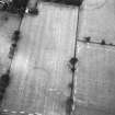
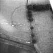
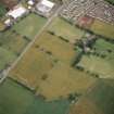
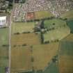
Westfield 1 NO 443 495 NO44NW
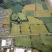
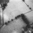
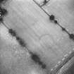
Cropmarks 130m SW of Westfield farmhouse reveal the SW half of a circular enclosure measuring 130m in diameter within a ditch up to 6m broad.
RCAHMS 1983.
Aerial Photographic Transcription (12 March 2021)
An interpretative transcription, or mapping, of information on oblique aerial photographs was produced on 9 October 2019.

