
Tealing 1


Cup And Ring Marked Stone (Neolithic) - (Bronze Age), Souterrain (Prehistoric), Souterrain (Iron Age)
Site Name Tealing 1
Classification Cup And Ring Marked Stone (Neolithic) - (Bronze Age), Souterrain (Prehistoric), Souterrain (Iron Age)
Canmore ID 33350
Site Number NO43NW 1
NGR NO 41221 38170
Datum OSGB36 - NGR
Permalink http://canmore.org.uk/site/33350


- Council Angus
- Parish Tealing
- Former Region Tayside
- Former District City Of Dundee
- Former County Angus
NO43NW 1 4121 3816.
(NO 4121 3816) Earth-house (NR)
OS 6" map, (1959).
This souterrain was accidentally discovered during agricultural operations in 1871. It is curved in plan, and the inner end is rounded; it appears to have been divided into two compartments at AA and CC, and is c 80' long. Its greatest width is 8 1/2', 5' from the inner end, and its maximum height is c 6'4". The sloping floor, where it is not
natural rock, seems to havee been paved. Finds included charcoal, animal bones, a piece of Samian ware, a bracelet, bronze rings, cinerary urn fragments, 10 querns, whorls, and remains of stone cups. It was not known in 1932 where these finds were, but in 1940, a fragment of Roman glassware from here was donated to the National Museum of Antiquities of Scotland (NMAS Accession no. FR 547).
Built into the N wall of the entrance passage, 2' from the doorway, is a cup-and-ring-marked stone measuring 3' by 2', and there is also a cup-marked stone 12' S of the entrance. It measures 4'6" x 2'6" x 6".
A hut circle lies just N of this stone.
When field investigated in 1958, Tealing Earth-house was found to be as described above, in a good state of preservation, and protected by a MoW enclosure fence. The two cup-and-ring marked stones mentioned were still in situ, but it was not possible to locate a third stone, described by
J R Allen 1881) as being in the E wall of the main chamber of the structure, with some apparently artificial scratching on it; nor was the hut circle found.
A Jervise 1875; J R Allen 1881; W A Thorpe 1940; J Curle 1932; A Young 1938.
The glass is from a 1st-2nd century 'pillar-moulded' bowl and the Samian is possibly 2nd century.
A S Robertson 1970.
Field Visit (11 July 1943)
Earthhouses, W of Tealing House.
Only one earthhouse can now be seen where two are marked on the 6" OS map, and no second one is known locally. This is presumably the one planned and described in PSAS (). When the Inventory Survey is made, this point should be verfiied by taking a large-scale tracing of the published plan to the site for comparison.
Visited by RCAHMS (AG) 11 July 1943.
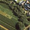
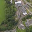
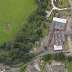
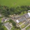
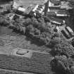
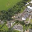
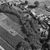
Aerial Photography (September 1970)
Oblique aerial photographs of Tealing souterrain, Angus, taken by John Dewar in September 1970.
Publication Account (1987)
Accidentally discovered in the course of agricultural operations in 1871, this site, cleared out with some care and subsequently enclosed for protection, displays many of the classic features of an Angus souterrain: a long curved passage, an expanded end and a constricted doorway. The excavations were recorded by Andrew ]ervise, the eminent Angus antiquary, though not undertaken by him; he mentions several interesting features including the discovery of fallen roofing slabs within the passage. The souterrain measures about 24.3 m in length, 2.3 m in average breadth, and the corbelled walls still stand to a height of 2 m, with large boulders forming the basal course and rather smaller horizontally-laid blocks above. The finds, although now lost, formed an interesting assemblage, including domestic debris such as animal bones, broken pottery and quern stones as well as fragments of Roman pottery and glass (the latter less certainly associated); the Roman finds are of lst or 2nd century AD date.
Near the entrance there is a large boulder decorated with cup-and-ring markings, which forms the lowest course of the wall on the north side.
Information from ‘Exploring Scotland’s Heritage: Fife and Tayside’, (1987).
Note (24 June 2019)
Date Fieldwork Started: 24/06/2019
Compiled by: ScRAP Team
Location Notes: The panel has been moved and reused within the structure of an Iron Age souterrain, known as Tealing Earthhouse which is a Property in Care. The panel forms part of the lowest row currently visible of the souterrain's N internal wall and lies approximately 1m W of the souterrain entrance. It is recorded under the same Canmore ID (33350) and HER reference (NO43NW0001) as Tealing 2 which is located approximately 5m to the S, also within the souterrain structure. As part of the souterrain, both panels are within the same scheduled monument designation (SM90299).
The souterrain lies in a flat area within a fenced enclosure lying within an area of arable land and pasture. The enclosure is located immediately to the W of a narrow strip of forestry running N-S over the line of Tealing burn, and beyond which lies Tealing village. It is reached by a path which is signposted from the road in the village and a path leads from Tealing Dovecot (Canmore 33373) through the woods and an open field, to the souterrain enclosure. The dovecot is approximately 60m to the SE.
There are open views across fields to the N and W with numerous houses visible to the N and NW.
Panel Notes: This is an irregular-shaped panel measuring 0.9 x 0.6m across its carved surfrace and lying within the wall of an Iron Age souterrain. It is not possible to meaures how far the panel extends into the wall because of its setting. The souterrain wall is approximately 1.1m in height at the location of the panel and the panel lies within its lowest course of the wall on its N side.
The panel surface is almost vertical, with its longest axis running W-E along the bottom of the wall. The is an area of fault running up and down the carved surface at a slope which is just off the vertical and which divides the panel surface into two sections, one lying to the W side and the other to the E. The upper edge of the panel describes a curved line with a dip in the middle, with the bottom of the dip marking the top of a fault running down the panel. The line of the panel's lower edge is obscured by being built into the ground.
The largest motif is found in the section of the panel to the W of the fissure running down the panel, and comprises a large (c.10cm) cupmark with three rings. The rings are largely complete, but partially disappear in a section of roughened rock to the NE of the cupmark. There is a further ring outside this which exists as two sections, one to the NW of the motif, where it follows the line of an expected fourth ring, and the other to the SE, where it deviates to a straight line running away from the motif. Also in the NW of this section, a further groove runs from outside this ring to the SW in a line, where it meets with a cupmark. There are three further cupmarks in the E section, and a further 6 single cupmarks in the section W of the fissure.

