
Invergordon, Royal Naval Dockyard, Housing


Military Housing (First World War)
Site Name Invergordon, Royal Naval Dockyard, Housing
Classification Military Housing (First World War)
Alternative Name(s) Golfview Terrace; Grosvenor Street; Elliot Road; Murray Road; Inglis Road; Cadboll Road
Canmore ID 331985
Site Number NH76NW 64.08
NGR NH 71702 69292
Datum OSGB36 - NGR
Permalink http://canmore.org.uk/site/331985


- Council Highland
- Parish Rosskeen
- Former Region Highland
- Former District Ross And Cromarty
- Former County Ross And Cromarty
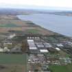
The First World War map of the Invergordon Naval Base (in a private collection) shows the presence of a housing estate of 126 cottages arranged along six streets. The clear implication of the map is that the houses were built for dockyard personnel (six houses for the dockyard’s officers are marked separately to the SW). The housing complex comprises uniform single-storey semi-detached cottages, with small porches, each with their own garden. The houses survive largely as built, although some have accumulated extensions, conservatories etc. The roads are now known as Golfview Terrace, Grosvenor Street, Cadboll Road, Elliot Road, Murray Road and Inglis Road.
Information from HS/RCAHMS World War One Audit Project (GJB) 2 August 2013.
Project (March 2013 - September 2013)
A project to characterise the quantity and quality of the Scottish resource of known surviving remains of the First World War. Carried out in partnership between Historic Scotland and RCAHMS.

