
Clyde Defences, Portkil Battery Land Defence, Gallow Hill, No 5 Position


Blockhouse(S) (First World War), Building (First World War), Latrine (First World War), Trench (First World War)
Site Name Clyde Defences, Portkil Battery Land Defence, Gallow Hill, No 5 Position
Classification Blockhouse(S) (First World War), Building (First World War), Latrine (First World War), Trench (First World War)
Canmore ID 331752
Site Number NS28SE 39.17
NGR NS 25677 81140
NGR Description Centred on NS 25677 81140
Datum OSGB36 - NGR
Permalink http://canmore.org.uk/site/331752


- Council Argyll And Bute
- Parish Rosneath
- Former Region Strathclyde
- Former District Dumbarton
- Former County Dunbartonshire
War Office maps of 1916 (The National Archives WO 78/4396) show that part of the outer defences of Portkil Battery occupied the summit of Gallow Hill. There were three blockhouses (pillboxes) one of which is shown as within a horse-shoe-shaped bank (No. 9 at NS 25587 81082). The northernmost blockhouse (No. 10 (at NS 25730 81192) is shown as lying with a complex of trenches (from NS 25682 81197 to 25751 81201 to NS 25747 81148). A third pillbox (also labled No.10, which may be a replacement for the orginal No.10) lay at NS 25721 81146. There was a field latrine to the west and an Officers' hut to the east (at NS 25772 81168). The northernmost pillbox is shown as being linked by telephone to the battery.
Information from HS/RCAHMS World War One Audit Project (GJB) 15 July 2013.
Project (March 2013 - September 2013)
A project to characterise the quantity and quality of the Scottish resource of known surviving remains of the First World War. Carried out in partnership between Historic Scotland and RCAHMS.
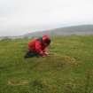
Field Visit (13 December 2016)
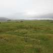
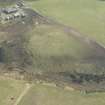
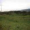
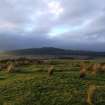
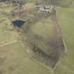
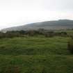
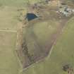
The First World War defences on Gallow Hill, a low rise that was once cultivated but is now given over to pasture, form part (No. 5 Position) of a larger infrastructure designed to protect the Portkil Coastal Battery (NS28SE 39) from its landward side (see also NS28SW 5, NS28SW 30, NS28SE 39.15 and 16).
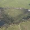
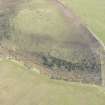
No. 5 Position comprises the remains of two blockhouses (No.9 and No.10), the former situated on the west flank of the hill, the latter on the summit, both of which are noted on a contemporary sketch-plan (National Archives: WO78/4396). Blockhouse No. 9 (NS 25627 81142) is largely situated on a WNW-facing natural terrace but its front stands on an artificial platform that extends out from the leading edge of the terrace by some 3m. The material for the construction of the front of this oval platform was probably gained from the excavation of the ditch that encloses the blockhouse. This ditch, which is broken by a causeway (1.5m wide) on the SSE, measures up to 16.5m in diameter internally from NE to SW by up to 2.5m in breadth and 0.6m in depth on the NE. From both sides of the causeway the ditch respectively runs around the SW and E/NE sides of the blockhouse to peter out on the edge of the terrace. Within the ditch, there is a grass-grown bank measuring 6m in diameter internally by up to 2.4m in thickness and 0.3m in height. There is a splayed entrance (1.7 – 3m wide) on the SSE and running along the spine of the bank for its entire length is a slot (0.4m-0.8m in width by 0.2m in depth) that once held the uprights of a timber fence or wall. Short slots, which extending out from this central slot to both the inner and outer edges of the bank at irregular intervals around the circuit, probably represent some form of support for the fence. Within the interior there are no visible remains of the timber building indicated on the sketch-plan.
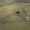
No. 10 Blockhouse (NS 25730 81168) was situated on the crest of the relatively flat summit of the hill, some 25m NE of its highest point. However, nothing is now visible of it other than a low scarp that possibly represents the outer edge of its SW side. The blockhouse was enclosed on the NW, NE and SE within what is now a shallow grass-grown trench, with arms that extend at least 27m to the WNW and 15.5m to the S respectively.
The contemporary sketch-plan depicts what it calls ‘No.10N blockhouse’ some 17m to the S. This may represent the building of a new blockhouse to replace the other, but there is nothing of the structure left to see at its site where there is now a pit measuring about 4.8m square and up to 0.4m in depth.
In addition to the blockhouses, the sketch plan depicts an ‘Officer’s Hut’ on the E flank of the hill and a ‘Field Latrine’ on the W flank. The site of the ‘Officer’s Hut’ (NS 25755 81146) was identified a short distance below and 25m SE of the original No. 10 blockhouse) and it comprises nothing more than a level stance measuring about 5m from WNW to ESE by 4m transversely and defined on the W and S by very low scarps cut into the natural slope. The ‘Field Latrine’ which is supposed to have stood about 25m NE of No. 9 blockhouse, was not identified at that location on the date of visit. However, situated 7.5m S of the blockhouse is a rectangular stance measuring about 2.5m from NW to SE by 2m transversely, which has been cut into the slope on the NW and NE, and which appears to have a drain running out from its SW side.
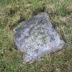
A granite boundary stone (NS 25723 81139) measuring 0.23m square is situated 6m SSW of the site of the secondary No. 10 blockhouse and is set into what are probably the remains of a prehistoric burial cairn (NS28SE 348). Its upper surface is flush with the turf and bears the incised inscription ‘W’ and ‘D’ to either side of an upward pointing arrow. Below this is what appears to be either the letter ‘H’ or, less likely, the number ‘11’ or ‘14’.
Visited by HES Survey and Recording (JRS, AM, AK) 13 December 2016.
Measured Survey (13 December 2016)
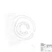
HES surveyed Blockhouse No.9, Portkil Battery (landward defences Position No.5) with plane-table and alidade on 13 December 2016 at a scale of 1:100. The resultant plan was redrawn in vector graphics software at a scale of 1:250.

