 |
On-line Digital Images |
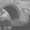
SC 1635737 |
List C Survey |
View from east
|
1975 |
Item Level |
|
 |
On-line Digital Images |
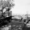
SC 1635738 |
List C Survey |
View from south |
1975 |
Item Level |
|
 |
On-line Digital Images |
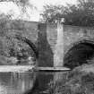
SC 1635741 |
List C Survey |
View from west |
1975 |
Item Level |
|
 |
On-line Digital Images |
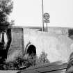
SC 1635783 |
List C Survey |
General view |
1975 |
Item Level |
|
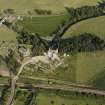 |
On-line Digital Images |
SC 1672989 |
RCAHMS Aerial Photography |
Dairsie Castle, oblique aerial view taken from the NW, centred on the remains of a castle, a church and Dairsie bridge. |
24/7/1996 |
Item Level |
|
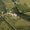 |
On-line Digital Images |
SC 1672990 |
RCAHMS Aerial Photography |
Dairsie Castle, oblique aerial view taken from the WSW, centred on the remains of a castle, a church and Dairsie bridge. |
24/7/1996 |
Item Level |
|
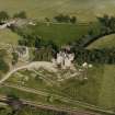 |
On-line Digital Images |
SC 1672994 |
RCAHMS Aerial Photography |
Dairsie Castle, oblique aerial view taken from the NW, centred on the remains of a castle, a church and Dairsie bridge. |
24/7/1996 |
Item Level |
|
 |
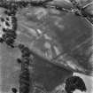
On-line Digital Images |
SC 1717036 |
RCAHMS Aerial Photography |
Filed in archaeology box file |
1992 |
Item Level |
|
 |
On-line Digital Images |
SC 1717037 |
RCAHMS Aerial Photography |
Filed in archaeology box file |
1992 |
Item Level |
|
 |
On-line Digital Images |
SC 2405414 |
Records of the Ordnance Survey, Southampton, Hampshire, England |
Dairsie Bridge, NO41NW 6, Ordnance Survey index card, page number 1, Recto |
1958 |
Item Level |
|
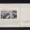 |
On-line Digital Images |
SC 2405415 |
Records of the Ordnance Survey, Southampton, Hampshire, England |
Dairsie Bridge, NO41NW 6, Ordnance Survey index card, page number 2, Verso |
1958 |
Item Level |
|
 |
On-line Digital Images |
SC 2405416 |
Records of the Ordnance Survey, Southampton, Hampshire, England |
Dairsie Bridge, NO41NW 6, Ordnance Survey index card, page number 3, Recto |
1958 |
Item Level |
|
 |
On-line Digital Images |
SC 2405417 |
Records of the Ordnance Survey, Southampton, Hampshire, England |
Dairsie Bridge, NO41NW 6, Ordnance Survey index card, Recto |
1958 |
Item Level |
|
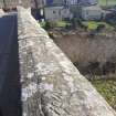 |
On-line Digital Images |
DP 402321 |
Historic Environment Scotland |
View looking SE of hammer and sickle graffiti, located toward the NW end of the SW parapet, Dairsie, Bridge, Fife. |
18/3/2021 |
Item Level |
|
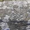 |
On-line Digital Images |
DP 402322 |
Historic Environment Scotland |
Hammer and sickle graffiti, located toward the NW end of the SW parapet, Dairsie, Bridge, Fife. |
18/3/2021 |
Item Level |
|
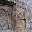 |
On-line Digital Images |
DP 402323 |
Historic Environment Scotland |
Extract from video of armorial panel, ascribed to James Beaton, Archbishop of St. Andrews, 1522-1538, located on the NE face of Dairsie, Bridge, Fife. |
14/10/2016 |
Item Level |
|
|
All Other |
551 166/1/1 |
Records of the Ordnance Survey, Southampton, Hampshire, England |
Archaeological site card index ('495' cards) |
1947 |
Sub-Group Level |
|


