 |
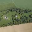
On-line Digital Images |
DP 016670 |
RCAHMS Aerial Photography Digital |
Oblique aerial view centred on the country house and stables, taken from the WSW. |
8/6/2006 |
Item Level |
|
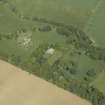 |
On-line Digital Images |
DP 016671 |
RCAHMS Aerial Photography Digital |
Oblique aerial view centred on the country house and stables, taken from the SW. |
8/6/2006 |
Item Level |
|
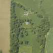 |
On-line Digital Images |
DP 016672 |
RCAHMS Aerial Photography Digital |
Oblique aerial view centred on the country house and stables, taken from the SE. |
8/6/2006 |
Item Level |
|
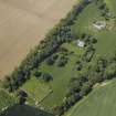 |
On-line Digital Images |
DP 016673 |
RCAHMS Aerial Photography Digital |
Oblique aerial view centred on the country house and stables, taken from the ESE. |
8/6/2006 |
Item Level |
|
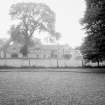 |
On-line Digital Images |
SC 1636504 |
List C Survey |
General view |
1975 |
Item Level |
|
 |
On-line Digital Images |
SC 2404859 |
Records of the Ordnance Survey, Southampton, Hampshire, England |
Gibliston Mill, Southern Range, NO40NE 4, Ordnance Survey index card, Recto |
1958 |
Item Level |
|


