
Tullich, St Nathalan's Kirk


Chapel (Period Unassigned), Church (Period Unassigned)
Site Name Tullich, St Nathalan's Kirk
Classification Chapel (Period Unassigned), Church (Period Unassigned)
Alternative Name(s) Tullich Church
Canmore ID 32454
Site Number NO39NE 2
NGR NO 39054 97543
Datum OSGB36 - NGR
Permalink http://canmore.org.uk/site/32454


- Council Aberdeenshire
- Parish Glenmuick, Tullich And Glengairn
- Former Region Grampian
- Former District Kincardine And Deeside
- Former County Aberdeenshire
Tullich carved stones, Aberdeenshire
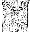
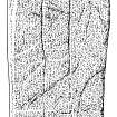
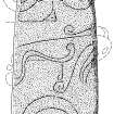
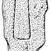
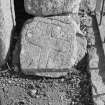
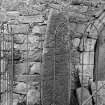
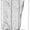
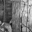
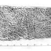
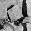
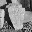
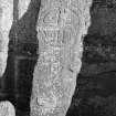
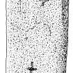
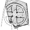
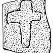
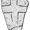
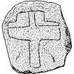
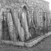
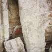
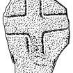
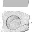
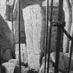
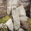
There are 17 extant early medieval carved stones at St Nathalan’s Kirk, Tullich, including one Pictish symbol stone and 16 cross-incised stones. Another stone, the East Cross (Tullich 17) is recorded but has been destroyed. The carved stones are mostly made from local granite. Some were recorded in the 1870s, and others were found in the twentieth century, but the first full survey was carried out by RCAHMS in 2004-5. Excavations were undertaken in 2013 by Hilary and Charles Murray, who with Jane Geddes published a full account of this early medieval church site and its carved stones in 2015. Most of the stones are personal memorials. Radiocarbon dates from the graveyard fall in the mid-seventh to late ninth centuries, when there is likely to have been a monastery here.
Geddes, Murray & Murray 2015.
Desk-based information compiled by A Ritchie 2019
NO39NE 2.00 39054 97543 St Nathalan's Kirk
NO39NE 2.01 39057 97533 Burial-Ground
NO39NE 2.02 39050 97548 Symbol Stone and Cross Slabs
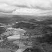
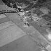
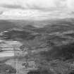
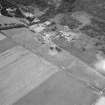
(NO 3905 9754) Church (In Ruins) (NAT) On Site of (NAT) St. Nathalan's Chapel (NR)
OS 6" map, (1938)
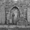
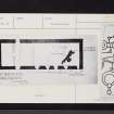
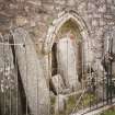
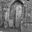
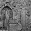
A Celtic chapel was established here by Nathalan (W D Simpson 1922), Nachalan (J G Michie 1910), or Neachtan (H Scott 1915-61) who died in AD 678. The church was held by the Knights Templars and latterly by the Hospitallers, (D E Easson 1957) who built a fort around the church in the 13th century, traces of which still remain (A I McConnachie 1898). The present building is a good example of a Medieval parish church, which has been very largely reconstructed in post- Reformation times. A late 14th century doorway remains in the N wall, but the precise date of construction is not known (W D Simpson 1922).
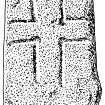
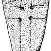
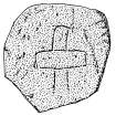
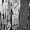
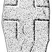
At the door of the church, surrounded by a railing, there is a Pictish symbol stone, found by Michie in 1866, built into the fabric of the church, five grave-slabs each inscribed with a Celtic cross, and an old font (J R Allen and J Anderson 1903). According to Michie, St. Nachalan's cross, a cross-inscribed stone, stood some distance to the E of the churchyard, but it was destroyed in 1857 for road metalling. However, Jervise states that St. Nach'lan's cross, which was 12' high and adorned with steps, was a square unadorned shaft of granite on the site of Nach'lans Fair and which was removed in 1817. (Probably a mis-print).
A Jervise 1875-9; A I McConnachie 1989; J R Allen and J Anderson 1903; J G Michie 1910; H Scott 1915-61; W D Simpson 1922; D Easson 1957.
A church, ruined but preserved, situated within a graveyard which is still used. As well as the Pictish symbol stone as described and illustrated by Allen (1903), and the font, there are now 16 Celtic-type cross-slabs within the railed enclosure on the N side of the church. They vary from 0.2m square to 1.5m in height.
Re-surveyed at 1/2500.
Visited by OS (N K B) 13 November 1968.
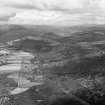
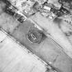
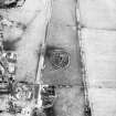
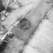
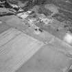
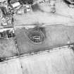
The W and S arcs of the modern circular graveyard wall are built upon a substantial stony bank, maximum height c. 1.0m. Outside this are traces of a slight ditch which can be traced around the periphery of the wall except in the N where there is an extension to the graveyard. From the crest of the bank to the top of the outer scarp of the ditch measures c. 4.5m. Apparently the alleged fortification, but probably only a minor protective dyke and drainage ditch.
Visited by OS (A A) 22 November 1968.
Class I symbol stone.
(Undated) information in NMRS.
Visible on air photographs AAS/93/02/G2/5-9; Copies held by Grampian Regional Council.
Information from Mrs M Greig, Dept. of Physical Planning, Grampian Regional Council, (March 1994).
Air and ground photographic imagery listed.
NMRS, MS/712/36, visited 12 July 1978, 24 July 1990 and 3 July 1992.
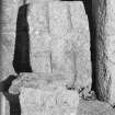
Between 2014-15, a display was created for carved symbol stones found on the site. Some of the carved stones now sit within a modern display structure to the east of the church.
Archaeological Evaluation (27 June 2016)
NO 39050 97540 Four small test pits were excavated, 27 June 2016, to examine the foundations of the wall of the ruins of Tullich Kirk prior to stabilisation work.
Archive: NRHE. Report: Aberdeenshire SMR and NRHE
Funder: NE Preservation Trust
Hilary and Charlie Murray – Murray Archaeological Services Ltd
(Source: DES)
Standing Building Recording (25 July 2018 - 26 July 2018)
NO 39054 97538 A historic building survey was undertaken,
25–26 July 2018, of the ruined church in advance of
consolidation works to stabilise the church, and is part of
wider initiative to embrace the heritage value and visitor
experience of the church.
Tullich Church dates from the 1400s and is situated over
the site of an earlier 7th-century church which is thought to
have been dedicated to St Nathalan. This earlier church was
then passed to the Knights Templar in the 1200s, who later
became the Knights Hospitaller to the Order of St John.
The present kirk is located within a roughly circular
churchyard wall and is fairly plain with little architectural
detail, due in most part to the hard granite rubble used in
its construction. Sandstone has been used for the door and
window surrounds on the S elevation, which are chamfered
and contain the internal slits for glazing panels on the insides
of the window surrounds. The church was abandoned in the
late 18th century in favour of a new kirk built in Ballater when
there was a joining of parishes in the area. The kirk was likely
stripped of its roof and furnishings at this time and was then
subdivided in the early 19th century into three burial aisles
for the Farquharson, Grant and Emslie families, with dates of
those interred or remembered there dating from 1826–1993.
Archive: NRHE (intended)
Funder: Aberdeenshire Council
Diana Sproat – AOC Archaeology Group
(Source: DES, Volume 19)

