
Hill Of Redhall


Cropmark(S) (Period Unknown), Settlement (Prehistoric), Souterrain (Prehistoric)(Possible), Track (Post Medieval), Unidentified Pottery(S) (Medieval)
Site Name Hill Of Redhall
Classification Cropmark(S) (Period Unknown), Settlement (Prehistoric), Souterrain (Prehistoric)(Possible), Track (Post Medieval), Unidentified Pottery(S) (Medieval)
Alternative Name(s) Summit
Canmore ID 32201
Site Number NO35NE 34
NGR NO 3971 5821
Datum OSGB36 - NGR
Permalink http://canmore.org.uk/site/32201


- Council Angus
- Parish Kirriemuir
- Former Region Tayside
- Former District Angus
- Former County Angus
NO35NE 34 3971 5821.
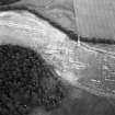
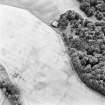
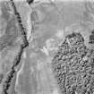
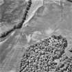
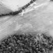
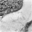
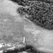
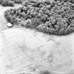
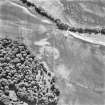
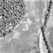
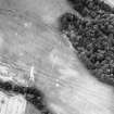
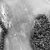
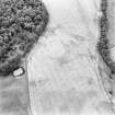
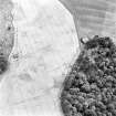
Cropmarks recorded by oblique aerial photography have revealed a circular settlement enclosure and various other cropmarks across a field immediately to the S of Hillend Plantation. The settlement, defined by a ditch up to 5m wide, has an internal diameter of about 42m with an entrance gap on the E side. A sub-circular mark and arc of ditch are visible internally, possibly round-houses with diameters of less than 10m. An L-shaped cropmark abutting the N side of the enclosure may be a souterrain measuring about 13m in length narrowing to where it hooks round to a probable entrance on the S. A second L-shaped feature runs from the exterior edge of the ditch curving round towards the settlement entrance. This site was previously interpreted as an enclosure. A linear cropmark running SSW from NO c.3980 5819 for some 105m is the continuation of a trackway depicted on the OS 1:10000 map sheet leading N to Airlie Lodge (NO35NE 1.04). Further cropmarks in the immediate area may represent cultivation remains and geological features.
Information from RCAHMS (KB) 2 March 2000
Field Walking (2006)
NO 398 582 Fieldwalking a ploughed field produced a few sherds of medieval redware pottery.
A Dick 2006

