
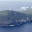
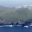
Rona, Toa Rona


Marker Cairn (Period Unassigned)
Site Name Rona, Toa Rona
Classification Marker Cairn (Period Unassigned)
Alternative Name(s) North Rona; Rona Ronaidh
Canmore ID 320001
Site Number HW83SW 15
NGR HW 81760 32273
Datum OSGB36 - NGR
Permalink http://canmore.org.uk/site/320001


- Council Western Isles
- Parish Barvas
- Former Region Western Isles Islands Area
- Former District Western Isles
- Former County Ross And Cromarty
Field Visit (2 July 2009)
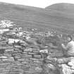
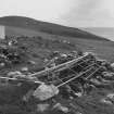
A built marker cairn stands on the summit of Tobha Ronaidh, the highest point on North Rona, due S of the array of solar panels supplying power to the lighthouse. It measures 2.7m in diameter by 1.2m in height where the masonry face is best preserved on the NW. On the S the face is beginning to collapse, while on the E a small structure comprising a single slab some 1m in length with other stones piled on top extends round its foot on to the NE. This has the appearance of a vermin trap, but in such a remote location is more likely to be an artificial nesting site. This cairn was apparently altered while the lightouse was being constructed in the 1980s and subsequently rebuilt.
The stones to build the cairn may have been taken from a heavily disturbed structure immediately to the SSE. Measuring 6m in diameter overall by 0.3m in height, it may be no more than a stand for stacking peats. The traces of a bank can be seen extending S towards the helipad and re-emerging on its S side (see HW83SW 14).
Visited by RCAHMS, SH & DCC 2nd July 2009

