
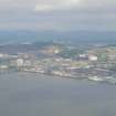
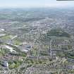
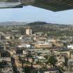
Dundee Law


Fort (Iron Age), Fortification (Medieval)
Site Name Dundee Law
Classification Fort (Iron Age), Fortification (Medieval)
Canmore ID 31936
Site Number NO33SE 32
NGR NO 3914 3131
Datum OSGB36 - NGR
Permalink http://canmore.org.uk/site/31936


- Council Dundee, City Of
- Parish Dundee (Dundee, City Of)
- Former Region Tayside
- Former District City Of Dundee
- Former County Angus
NO33SE 32.00 3914 3131
NO33SE 32.01 NO 3914 312 War Memorial
(NO 3914 3131) Fort (NR)
OS 1:10,000 map, (1975)
The fort occupying the summit of Dundee Law was badly disturbed during the construction of the war memorial (NO33SE 32.01) in 1923, when the S end was completely destroyed. The N rampart, although cut through by a path at one point, is now the most intact; it is 5.4m thick. The lines of the E and W ramparts also survive to some extent.
Christison's (1900) plan of 1899 shows a rectangular structure with what may have been an annexe at the N end. Overall, the fort, which occupied the whole of the summit of the Law, measured 79.2m x 51.8m, and its defences were so rectilinear in form that he compared it to Roman works. He also noted that, in the inner area, 'A' was slightly raised above 'B'. He claimed that the ramparts were largely of earth, but since that time the fort has been included in several lists of Scottish vitrified forts. Also, in 1964, during the erection of a television mast at the N edge of the summit, a mechanical excavator revealed two almost parallel lines of boulders, 2'6" below the surface, along the line of the rampart.
The only known artifact from the fort - a steatite cup-shaped lamp, found when excavating for the war memorial - is in Dundee Museum. (Acc No: 1964-55).
Warden (1880-5) notes that the forces of Edward I, Montrose, and Monk occupied the Law, and their entrenchments must have considerably changed the original appearance of the work.
A J Warden 188-5; D Christison 1900; H Coutts 1970; 1971; J D Boyd 1964.
Though the S, and much of the E, limits of the fort as planned by Christison have been destroyed, and the site considerably mutilated, its rectangular form is still apparent. The N rampart is best preserved, 9.0m in width overall and 1.75m maximum height. A small brick building at NO 3914 3133 breaks the outer scarp very slightly, and a modern path 2.25m wide cuts through the rampart at NO 3915 3133. E of this break, the rampart projects for some way as shown on Christison's plan, and continues downhill to merge with the natural slopes. The counter-scarp of the E bank has been considerably destroyed, while its scarp slope remains 1.75m high, extending S to the edge of the road and gradually decreasing in height. Part of the counter-scarp remains near the S end, 0.5m high. Of the W rampart, the scarp remains 1.0m high, and the counter-scarp 0.6m high in the N. This bank curves noticeably westwards towards the S end, but his may be the result of modern mutilation.
These banks are mainly of earth and small stones. The interior is uneven, and slopes downwards towards the E. The slightly raised platform - 'A' on Christison's plan - can just be noticed, but is not surveyable. Occasional protruding stones on the N and W edges of the summit suggest the annexe noted by Christison.
Two or three vitrified stones, said to be from the Law, are in Dundee Museum, the details of the finds being unknown to Mr Boyd (curator, Dundee Museum).
The work is probably in Iron Age fort, having medieval alterations as suggested by Warden.
Visited by OS (J L D) 17 April 1958.
Excavations occassioned by environmental improvements have revealed fortifications on the summit dating from two widely separated eras. The first fortifications date from the Iron Age and were severely burnt and vitrified; the later earthwork fortifications were probably raised in the 16th century. Consideration is given to the form of the later earthworks and the historical significance of the Law to Dundee.
S Driscoll 1995.
Incident (1923)
The fort occupying the summit of Dundee Law was badly disturbed during the construction of the war memorial (NO33SE 32.01) in 1923, when the S end was completely destroyed.
Coutts, 1970
Field Visit (5 August 1956)
This site was included within the RCAHMS Marginal Land Survey (1950-1962), an unpublished rescue project. Site descriptions, organised by county, are available to view online - see the searchable PDF in 'Digital Items'. These vary from short notes, to lengthy and full descriptions. Contemporary plane-table surveys and inked drawings, where available, can be viewed online in most cases - see 'Digital Images'. The original typecripts, notebooks and drawings can also be viewed in the RCAHMS search room.
Information from RCAHMS (GFG) 19 July 2013.
Reference (1964)
During erection of a television mast at N edge of summit in 1964, two almost parallel lines of boulders were discovered 2 ft 6 ins. (0.76m) below the surface and circa 4ft (1.22m) from the steep side of the hill. Boyd (1964) comments that these boulders lie along the line of the supposed rampart of the fort. Speculatively, the discovery may have formed part of the rounded annexe at the N end of the Law summit which Christison (1900-01) describes as following the contour of the hill there.
Resistivity (February 1990 - March 1990)
An assessment of the archaeological potential of the fort was carried out in February and March 1990. A resistivity survey of the internal area followed by trial-trenching designed to locate internal structures proved inconclusive. The N and W ramparts, and part of the internal area were investigated and dating samples were recovered. Finds included a perforated stone and pieces of slag.
Sponsors: Dundee District Council; HBM.
J S Rideout 1990.
Excavation (1993)
Excavations were conducted prior to the construction of environmental improvements on the summit of Dundee Law. It has long been recognised that traces of a rectilinear fortification survived on the summit, which has been variously dated to the Iron Age, the 14th century and the 17th century. Before the excavation, archival work brought to light a mid 19th-century map, which revealed that formerly there were clearly-defined bastions at the corners of the fortification. These plans did not fully resolve the question of date, but seemed to cast doubt on the reports of the presence of a vitrified fort. The problem was compounded by the fact that the southern end of the fort including its original entrance in the SE corner, is now obscured by the War Memorial (NO33SE 32.01) and the modern road, while the earthworks are evidently much less sharp than they were last century.
Two trenches were excavated in February, both of them being on the summit and in areas where the improvements would encroach upon the scheduled area. In addition, the opportunity was taken to make a plane table survey of the earthworks which are not as regular as is represented on any of the published plans.
The E trench was located just N of the point where the modern road reaches the summitt. Here the eastern bank, which survives as an earthwork, was exposed and the threatened portion was removed. It proved to be mostly composed of earth. On the inner side of the bank, a linear setting of stones may represent the foundations of a revetting feature. Quantities of stone rubble were found spread over the interior, including two linear stone features set at approximately right angles to the line of the bank. These linear features may relate to entrance structures. A metre-wide slot was excavated through the stony spread of the interior to a depth of approximately 0.3m. The deposits were not bottomed and no further excavation was undertaken, but rather measures were taken to ensure that the archaeological deposits were not disturbed during the construction works. No finds which might have helped to date the earthworks were recovered, but within this trench a rectangular pit was excavated, which contained large quantities of vitrified stones mixed with modern debris. The pit is probably a soak-away drain dug at the time of the construction of the War Memorial. The vitrified stone confirms earlier reports, but had no link with the defences that were revealed in this area. It must be presumed that they were recovered from the area now occupied by the War Memorial.
The W trench provided an opportunity to completely section the western earthwork bank. Here again, it was composed largely of earth with a moderate fraction of small stones. Upon clearing the bank away, areas of intense burning were revealed. The natural subsoil had been scorched red and traces of structural remains were also apparent at this lower level. In order to pursue this level further, a further period of excavation and a watching brief were arranged, which was undertaken during July. This extension revealed an area of rough paving sealed by a layer of charcoal and ash, which is likely to be the same burnt deposit seen in the original excavation. The burnt materials slumped into an irregular oval pit which had been cut through the paving. Within the burnt deposits, three fragments of terra sigillata and a whale vertebra were recovered.
It now seems probable that the site does indeed contain a vitrified fort, which was occupied, if not constructed, in the 1st to 2nd century AD. The earthwork defences which are visible today apparently represent a refortification in the medieval or early modern period, but no artefacts were recovered to shed light on this problem. Radiocarbon dates are awaited which should help to date the demise of the Iron Age fort and might provide a clue as to the construction of the later fort.
Sponsors: Dundee District Council, Scottish Enterprise Tayside.
S T Driscoll 1993
Note (21 May 2015 - 15 August 2016)
Little is visible of the fort that stood on the summit of Dundee Law, which was adapted in the 16th or 17th centuries for a rectangular artillery fortification, and further demolished in 1923 for the construction of a war memorial; other damage has been caused by telecommunication installations erected over the N end. Nevertheless, the first town plans surveyed for Dundee in the mid 19th century clearly depict the artillery fortification, with bastions at each of its four corners, set squarely across a subrectangular enclosure measuring in the order of 70m from N to S by 30m transversely within its rampart (0.18ha). Vitrified stones found during the construction of the war memorial and in an excavation in 1993 suggest that this earlier rampart was timber-laced, though the rampart itself was not located in 1993, when partial sections were cut across what are probably elements of the earthwork defences of the artillery fort (Driscoll 1995). An area of intense burning was located on the W side of the interior, however, returning a radiocarbon date of 770 to 370 cal BC, while a stratified sequence of deposits was also recorded in which a pit containing three sherds of 1st century AD samian ware had been cut through an earlier area of paving and sealed by another burnt deposit, in this case dating from 40 cal BC to cal AD 220. A similar spectrum was returned by three dates from internal deposits located in an earlier evaluation carried out in 1990 (Rideout 1990). The only other feature of note is that the early OS maps of Dundee Law show a scarp encircling the foot of the hill, but there is no evidence that this is an ancient enclosure and fieldwork in 1993 found only old field banks on the lower slopes (Driscoll 1995).
Information from An Atlas of Hillforts of Great Britain and Ireland – 15 August 2016. Atlas of Hillforts SC3068

