
Moat Knowe


Building (Period Unassigned), Sheepfold (Period Unassigned)
Site Name Moat Knowe
Classification Building (Period Unassigned), Sheepfold (Period Unassigned)
Canmore ID 318645
Site Number NT71SE 202
NGR NT 78000 13613
Datum OSGB36 - NGR
Permalink http://canmore.org.uk/site/318645


- Council Scottish Borders, The
- Parish Hownam
- Former Region Borders
- Former District Roxburgh
- Former County Roxburghshire
Field Visit (6 October 1999)
NT71SE 202
Moat Knowe
Building; Sheepfold
NT 78000 13613
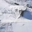
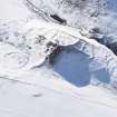
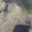
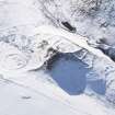
Situated on gently sloping ground, about 20m to the E of the scooped settlement at Buchtrig (NT71SE 25), there are the footings of a turf building and a sheepfold. The building (NT 78000 13613) measures 5.8m from N to S by 2.6m transversely within turf and stones walls up to 0.3m in height and 1m in thickness. The sheepfold (NT 78045 13615) lies about 25m to the E, is rectangular on plan and measures 41m from ESE to WNW by 6m transversely; there are three internal compartments. A rectangular sheepfold is depicted on the 1st edition of the OS 6-inch map (Roxburghshire 1863, xxviii). Turf banks extend to the NNW of the building for a distance of about 110m, roughly following the modern fence line (from NT 78000 13616 to NT 77947 13715). To the E and S of the sheepfold, turf banks extend for a distance of about 240m (from NT 78077 13622 to NT 78108 13447). Both structures are now partially overlain my modern fences and a sheepfold.
(KALE99 420)
Visited by RCAHMS (DCC) 6 October 1999, with additional information from RCAHMS (BM) 12 June 2012

