|
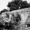
Photographs and Off-line Digital Images |
F 12128 |
List C Survey |
Wall |
1975 |
Item Level |
|
|
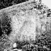
Photographs and Off-line Digital Images |
F 12129 |
List C Survey |
Wall |
1975 |
Item Level |
|
|
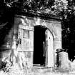
Photographs and Off-line Digital Images |
F 12130 |
List C Survey |
Temple/Garden House |
1975 |
Item Level |
|
|
Photographs and Off-line Digital Images |
DP 124029 |
Buildings at Risk Register |
Temple Knowe Garden House Side/ rear elevation |
17/12/2010 |
Item Level |
|
|
Photographs and Off-line Digital Images |
DP 124030 |
Buildings at Risk Register |
Temple Knowe Garden House Front elevation |
25/3/2009 |
Item Level |
|
|
Photographs and Off-line Digital Images |
DP 124031 |
Buildings at Risk Register |
Temple Knowe Garden House Side elevation |
25/3/2009 |
Item Level |
|
|
Photographs and Off-line Digital Images |
DP 203860 |
Buildings at Risk Register |
From North |
12/6/2014 |
Item Level |
|
 |
On-line Digital Images |
SC 1636019 |
List C Survey |
Wall |
1975 |
Item Level |
|
 |
On-line Digital Images |
SC 1636020 |
List C Survey |
Wall |
1975 |
Item Level |
|
 |
On-line Digital Images |
SC 1636021 |
List C Survey |
Temple/Garden House |
1975 |
Item Level |
|
|
Photographs and Off-line Digital Images |
DP 282858 |
Historic Environment Scotland |
View from North West |
18/10/2018 |
Item Level |
|
|
Photographs and Off-line Digital Images |
DP 282859 |
Historic Environment Scotland |
View from North East |
18/10/2018 |
Item Level |
|
 |
On-line Digital Images |
SC 2402968 |
Records of the Ordnance Survey, Southampton, Hampshire, England |
Cupar, Bonnygate, Temple Knowe Garden House, NO31SE 56, Ordnance Survey index card, Recto |
1958 |
Item Level |
|


