
Edenwood


Temporary Camp (Roman)
Site Name Edenwood
Classification Temporary Camp (Roman)
Canmore ID 31521
Site Number NO31SE 39
NGR NO 35761 11593
NGR Description Centred NO 35761 11593
Datum OSGB36 - NGR
Permalink http://canmore.org.uk/site/31521


- Council Fife
- Parish Ceres
- Former Region Fife
- Former District North East Fife
- Former County Fife
NO31SE 39 centred 35761 11593
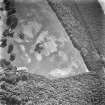
A 63-acre temporary camp, recorded during aerial survey.
RCAHMS 1978; R Goodburn 1979.
The camp that was identified at Edenwood, Fife (by RCAHMS and CUCAP) during reconnaissance in 1978 may be added to series of large marching-camps for which a Severan date has been proposed. It is situated on the right bank of the River Eden about 3km from Cupar. Almost the whole of the SE side, the central sector of the SW, two-thirds of the NW and a short length of the NE have been recorded on photographs taken over several years. As to entrances, an approximately central entrance has been seen in each of the NW and SE sides, and there are two entrances in the SW side; each entrance has a traverse. The rampart survives as an earthwork for a length of 130ft (39.5m) in a wood on the NW side, near the W angle, and for a short length on the NE side near the E angle. The axial dimensions of the camp are approximately 629m from NW to SE, by 399m, an area of about 25 ha (62 acres). An annexe is attached to the NW side between the entrance in that side and the W angle. Its dimensions are 106m from NW to SE by about 122m; it has its own NW entrance. The size of this camp and the presence of an annexe show that Edenwood belongs to the 25 ha (63 acre) series, of which Auchtermuchty, 12km (8.1 Roman miles) to the west, is the nearest known example
G S Maxwell and D R Wilson 1987.
Excavation by Glasgow University Archaeological Research Division in the SE corner showed that on the S side, the ditch was 0.8m deep and up to 3m wide, with a V-shaped profile; a large boulder had been left in situ along its line. The E ditch could not be located in the expected position; aerial photographs suggest it may have been left unfinished hereabouts.
L J F Keppie 1996
An archaeological watching brief was undertaken by Glasgow University Archaeology Research Division in June and July 1995 during a programme of work to install a new water trunk main between Glenrothes and Cupar. The watching brief identified significant concentrations of sensitive archaeological remains at three discrete locations: Kirkton, North Scotstarvit and Edenwood.
NO 3587 1136 Enclosing an area of about 62 acres, the camp is generally considered to be of early 3rd-century AD date, and a product of the Severan Campaigns in Scotland. The route of the pipeline crossed the SE corner of Edenwood Roman marching camp and it was anticipated, working from aerial photographic evidence, that the perimeter ditch would be encountered at two points within the pipeline corridor: the first along the S portion of the ditch before the SE corner, and the second just beyond the SE corner along the length of the E side. At the first point the ditch was found as anticipated, running diagonally through the corridor for a distance of 15m. A portion of the ditch was excavated to reveal it had a V-shaped profile, 3m wide and 0.8m deep. However, in the second area where the E return of the ditch was anticipated, no indication of its presence was observed after topsoil removal. The aerial photographs show the cropmark to be very indistinct at this point, perhaps indicating that the line of the ditch here was incomplete.
Sponsor: Fife Regional Council Engineering Department.
G MacGregor 1996.
Aerial Photographic Transcription (6 September 1990 - 17 December 1990)
An aerial transcription was produced from oblique aerial photographs. Information from Historic Environment Scotland (BM) 31 March 2017.
Publication Account (17 December 2011)
The camp at Edenwood was first discovered from the air in 1978 by both St Joseph and Maxwell independently (Goodburn 1979: 274; RCAHMS 1978b: 37). It lies some 2km south-west of Cupar on relatively flat land on the northwest side of the Hill of Tarvit, close to the River Eden.
The camp measures 635m from north-west to southeast by 400m, enclosing almost 25ha (61 acres). Entrances protected by tituli are known on the north-west and south-east sides, with two on the south-west side; there were probably six in total. An annexe is visible on the north-west side, measuring 106m by at least 106m enclosing a further probable 1.1ha (2.8 acres). Although the camp is mostly known from cropmark remains, two small earthwork stretches have survived in woodland: on the north-east side close to the east corner, and on the north-west side in Greenrig Wood running towards the west angle. The rampart on the north-east side is 0.3m high and spread about 4.4m wide.
Excavations by St Joseph and Maxwell in 1978–9 recorded that the ditch was up to 3.8m wide and 2.1m deep on the north-east side, but elsewhere its depth averaged c 1m. The ditch of the annexe was up to 3.3m wide and 1.3m deep (RCAHMS St Joseph Collection: Notebook 8).
Excavations by MacGregor in 1995 recorded the V-shaped ditch on the south-west side measuring up to 3m wide and 0.8m deep, possibly backfilled with rampart material. However, excavations on the south-east side close to the south corner appeared to record a natural break in the ditch. Three pits were also revealed, two of which showed evidence of burning, although no dating evidence could be obtained (MacGregor and Leslie 1998).
R H Jones

