
Preston Toll


Roundhouse (Prehistoric)
Site Name Preston Toll
Classification Roundhouse (Prehistoric)
Canmore ID 313663
Site Number NT46NW 161
NGR NT 41321 65748
Datum OSGB36 - NGR
Permalink http://canmore.org.uk/site/313663


- Council East Lothian
- Parish Ormiston
- Former Region Lothian
- Former District East Lothian
- Former County East Lothian
NT46NW 161 41321 65748
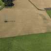
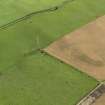
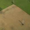
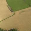
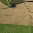
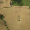
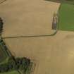
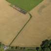
This roundhouse has have been recorded as a cropmark on oblique aerial photographs (RCAHMSAP 2009). It is circular in plan and defined by a ditch about 0.95m wide. The enclosed area is 14m in diameter, but the W section of the ditch, where there may have been an entrance, is indistinct. Eight pits are visible in the interior.
Information from RCAHMS (KHJM) 28 Oct 2011
Aerial Photographic Transcription (28 October 2011)

