
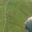
Unst, Middleton


Farmstead (Period Unassigned)
Site Name Unst, Middleton
Classification Farmstead (Period Unassigned)
Canmore ID 313116
Site Number HP50SE 125
NGR HP 5757 0411
Datum OSGB36 - NGR
Permalink http://canmore.org.uk/site/313116


- Council Shetland Islands
- Parish Unst
- Former Region Shetland Islands Area
- Former District Shetland
- Former County Shetland
Field Visit (January 1970 - December 1991)
A survey of deserted settlements in Unst by June Owers. The survey includes photographs, sketches and historical information.
Note (23 September 2011)
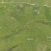
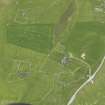
A plan of Middleton was drawn by June Owers in her survey of deserted settlements in Unst (1970). It depicts a farmstead aligned NW-SE comprising an unroofed stone built long range of three compartments. A former croft house at the SE end has a central doorway amd flanking windows on its SW side, and a further window in the NE wall. Fireplaces are depicted in each of the croft house gables.
A farmstead comprising one roofed long building within an enclosure is depicted on the 1st edition of the OS 6-inch map (Orkney and Shetland (Shetland) 1882, sheet viii).
Information from RCAHMS (BRW) 23 September 2011

