
Skye, Ard Snaosaig


Building (Period Unassigned)
Site Name Skye, Ard Snaosaig
Classification Building (Period Unassigned)
Canmore ID 311795
Site Number NG71SW 18
NGR NG 7013 1068
NGR Description Centre of site
Datum OSGB36 - NGR
Permalink http://canmore.org.uk/site/311795

- Council Highland
- Parish Sleat
- Former Region Highland
- Former District Skye And Lochalsh
- Former County Inverness-shire
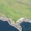
A poorly preserved rectangular building measuring 14m x 4.5m was recorded during a pre-afforestation survey by Wordsworth Archaeological Services in November 2000 (site 5). The walls stand up to 0.5m high, but are badly obscured by bracken. The building is aligned N - S and there may be an entrance in the E wall, towards the N end. It was suggested that small fragments of drystone walling below the SW corner of the dun, NG71SW 2, are probably connected to this building rather than the dun.
Aerial photography shows a building matching this description c50m W of the given grid reference at NG 70075 10691 and two smaller buildings on a similar alignment lying c50m NW (NG70125 10735) and c50m WNW (NG70137 10703), respectively.
Information from Ishbel MacKinnon, July 2011.

