
North Cuil


Fishing Bothy (19th Century)-(20th Century)
Site Name North Cuil
Classification Fishing Bothy (19th Century)-(20th Century)
Canmore ID 309215
Site Number NM95NE 8.08
NGR NM 9756 5543
Datum OSGB36 - NGR
Permalink http://canmore.org.uk/site/309215


- Council Highland
- Parish Lismore And Appin (Lochaber)
- Former Region Highland
- Former District Lochaber
- Former County Argyll
Reference (1 August 2008 - 1 August 2009)
Old maps and photographs.
Field Visit (1 August 2008 - 1 August 2009)
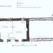
Site inspection internally and externally: measured.
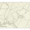
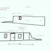
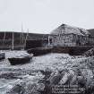
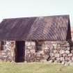
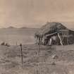
This building is shown on Bedford's marine charts of 1861 and 1867 as well as the first (1875) and second (1897) OS 6-inch map (Argyllshire and Buteshire, sheet xliii). It is shown on two of Erskine Beveridge's photographs taken on 14th July 1883. They show that it was much larger than it is now with two doors and two small outlets for smoke. It was thatched. The seaward corners were square but photographs taken a shortly after 1950 show the inland corners to be rounded. Looking at the front (north-east) wall a line can be seen to the right of the right hand window. To the right of this line the stones are larger and rounded and to the left they are smaller and more rectangular. I conclude that it was originally built with four round corners but the seaward end was much damaged by a winter storm and had to be rebuilt. This was done in a more modern style. The inland end has also suffered damage and by the time of the 1950s photograph the walls were shoulder high but there was no roof to this part. The doorway could still be seen. Within this area there were several sheds. By this time the seaward gable end had been reconstructed to include a chimney. Although there is a hearth at the other end there does not appear to have ever been a chimney here. The style of thatching is different from that of the earlier photographs. The walls are of drystone construction with a little cement added in the late 1960s. By the end of the 1950s the roof was in a very sad state and had to be replaced. At this time it was not possible to obtain thatch or find a thatcher and, therefore, a corrugated iron roof was installed. Three of the four crucks are still in position and the fourth slot is in good condition. Internally it is divided by a wooden partition. The floor is cobbled with a large slate slab at the threshold. On the outside of the building, especially the back, several iron pegs for holding down the thatch can still be seen. The chimney was removed and replaced by an external tubular iron lum which has subsequently been eliminated. It was lived in during the salmon fishing season until the 1950s. Now it is used to store fishing nets and other equipment.
Pont's map of about 1595 shows a fish heading for the mouth of the river Duror and the accompanying text states that the river was good for salmon. I think it can be presumed that salmon fishing of one sort or another has been carried on for over 400 years. At one time people used to come here to learn how to set out the nets. The traditional bag net is still used although for a shortened season to try to maintain the salmon stocks. The netyard lies to the north-west of the building.
A well shown on the first Ordnance Survey map to the north-west of the bothy has ceased to exist for the past fifty years. The water level was reputed to rise and fall with the tide.

