 |
On-line Digital Images |
SC 1225245 |
Scotland's Rural Past |
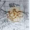
Timothy Pont's Map: circa 1595. |
1/12/2010 |
Item Level |
|
 |
On-line Digital Images |
SC 1225246 |
Scotland's Rural Past |
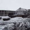
1883 Erskine Beveridge Photograph: RCAHMS Collection. |
1/2/2010 |
Item Level |
|
 |
On-line Digital Images |
SC 1225247 |
Scotland's Rural Past |
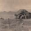
1952 photo of Bothy showing rounded inland corner. |
1/2/2010 |
Item Level |
|
 |
On-line Digital Images |
DP 093768 |
Scotland's Rural Past |
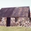
Bothy nowadays: note difference in building styles. |
1/2/2010 |
Item Level |
|
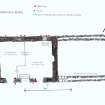 |
On-line Digital Images |
SC 1225254 |
Scotland's Rural Past |
Plan of Fisherman's Bothy. |
1/2/2010 |
Item Level |
|
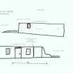 |
On-line Digital Images |
SC 1225255 |
Scotland's Rural Past |
Fisherman's Bothy: elevations. |
1/2/2010 |
Item Level |
|
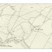 |
On-line Digital Images |
SC 1225289 |
Scotland's Rural Past |
1st edition of the OS 6-inch map (Argyllshire and Buteshire 1875, sheet xliii) extract |
1/2/2011 |
Item Level |
|
 |
Digital Files (Non-image) |
WP 000358 |
Scotland's Rural Past |
Cuil Survey report. Neill Malcolm 2012 |
14/2/2012 |
Item Level |
|


