
Finlaystone Point, Timber Ponds


Timber Pond(S) (18th Century)
Site Name Finlaystone Point, Timber Ponds
Classification Timber Pond(S) (18th Century)
Alternative Name(s) River Clyde; Finlaystone House; Langbank Mast Ponds; Inner Clyde Nature Reserve
Canmore ID 307418
Site Number NS37SE 74
NGR NS 3692 7395
NGR Description Centred NS 3692 7395
Datum OSGB36 - NGR
Permalink http://canmore.org.uk/site/307418


- Council Inverclyde
- Parish Kilmacolm
- Former Region Strathclyde
- Former District Inverclyde
- Former County Renfrewshire
NS37SE 74 centred 3692 7395
Timber Ponds (disused) [NAT]
(centred NS 3661 7409 and NS 7370 7383)
OS (GIS) MasterMap, March 2011.
Extend into (assigned) Kilmacolm parish: within intertidal zone.
Location formerly entered as NS 3402 7432 to NS 3759 7377.
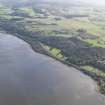
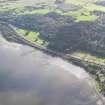
This extensive array of mast or timber ponds extends for some 1.4km along the SSW foreshore of the River Clyde, between NS c. 3626 7429 and NS c. 3760 7380. It fronts parts of both Kilmacolm parish (to the W) and Erskine parish (to the E), and is assigned to these administrative areas although it is situated within the intertidal zone.
Information from RCAHMS (RJCM), 22 March 2011.
Scheduled as 'Finlaystone House, timber ponds 505m NE of... part of a system of interconnected square and rectilinear timber ponds formed by vertical timber posts. Standing on the S foreshore of the Clyde estuary between Port Glasgow and Langbank, these ponds date to the early or mid 18th century and were in use probably into the early 19th century. They functioned as storage for timber imported to Greenock and Port Glasgow from North America before its sale to local shipyards.'
Information from Historic Scotland, scheduling document dated 31 March 2011.
The location assigned to this record is essentially arbitrary.
Finlaystone House (NS37SE 3.00) is at NS 36458 73717.
Information from RCAHMS (RJCM), 3 June 2011.
Project (May 2016 - September 2017)
Running from May 2016 to September 2017 and part of the Canmore Mapping Programme, Yard by Yard was an area-focused, desk-based project that tested the Defining Scotland’s Places (DSP) methodology in an area for which the records in the NRHE showed considerable variation from one historic map source to another.
Following discussions with local heritage groups and with the ambition of collecting data useful to the communities’ ambition to develop a coastal heritage trail, the project aimed to map the extent of the shipyards and associated industry between Port Glasgow and Greenock. To achieve this aim, the project used historic mapping, ortho-rectified modern aerial photography and the HES aerial photograph collection to map the extents of, and upgrade the records of, the shipyards and associated features such as quays, docks, areas of land reclamation and associated industry.

