
Sanday, Pool


Fish Trap (Period Unassigned)(Possible), Harbour (Period Unassigned)(Possible), Natural Feature (Period Unknown)(Possible)
Site Name Sanday, Pool
Classification Fish Trap (Period Unassigned)(Possible), Harbour (Period Unassigned)(Possible), Natural Feature (Period Unknown)(Possible)
Canmore ID 306721
Site Number HY63NW 76
NGR HY 6180 3780
Datum OSGB36 - NGR
Permalink http://canmore.org.uk/site/306721


- Council Orkney Islands
- Parish Cross And Burness
- Former Region Orkney Islands Area
- Former District Orkney
- Former County Orkney
Field Visit (1999)
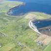
A possible fish trap or basin is located in the intertidal zone adjacent to the excavated settlement on the east side of Pool Bay. Here, at low tide, a body of water is almost completely encircled by stony reefs. It is not clear whether or not this is a natural feature but it shares similarities to fish traps seen elsewhere and may at least be a natural feature which has been enhanced through clearing or deepening the central pool. The enclosed area measures some 60m in length by 30m in width.
Moore & Wilson 1999.
Coastal Zone Assessment Survey, 1999
Field Visit (August 2014)
At the beach end of the reef a wall has been built that has the effect of enclosing some of the pool of water. The wall is built of substantial blocks of stone three to four courses in height. Max height approximately one metre. The wall is still vertical on the southern side, but less clear on the interior of the pool. It runs for 15 to 20m in line with the outside edge of what seems to be a natural reef and joins it to the land. On a falling tide there is higher water inside the reef than externally elsewhere in the bay. A narrow exit to the sea through the far end of the pool may or may not be natural. The pool here has long been known locally as a "Viking harbour", and further information supplied recently states that the pool was in frequent use for landing small boats until recent years. Thus this may also be a harbour or landing place.
Information supplied by Julie Gibson

