
Rousay, Bigland


Treb Dyke (Prehistoric)
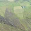
Site Name Rousay, Bigland
Classification Treb Dyke (Prehistoric)
Alternative Name(s) Sourin; Rousay
Canmore ID 306445
Site Number HY43SW 64
NGR HY 43650 32170
Datum OSGB36 - NGR
Permalink http://canmore.org.uk/site/306445

- Council Orkney Islands
- Parish Rousay And Egilsay
- Former Region Orkney Islands Area
- Former District Orkney
- Former County Orkney
Orkney Smr Note (July 1986)
This treb was observed by Mrs J Marwick when the farmer at
Bigland levelled a rabbit warren in the rough grass field
immediately SW of the end of the track past Bigland farm. The
warren was established in a broad bank running SW-NE. Where this
bank is cut by the fence on the SW side of the track it is 0.3m
high and spread to 8m wide, composed of dark earth. This
material can be seen continuing as a raised strip SW across the
field where the turf has been stripped off. NE from the track
the treb can be detected as a low, mutilated bank across a level
area of sheep-cropped turf.
Information from RGL July 1986.
This dyke is not too far from HY43SW 31

