
Threipmuir


Farmstead (Period Unassigned), Horse Engine (19th Century), Rig And Furrow (Medieval) - (Post Medieval), Rubbish Pit (19th Century) - (20th Century)
Site Name Threipmuir
Classification Farmstead (Period Unassigned), Horse Engine (19th Century), Rig And Furrow (Medieval) - (Post Medieval), Rubbish Pit (19th Century) - (20th Century)
Alternative Name(s) Threipmuir Farm
Canmore ID 306371
Site Number NT16SE 26
NGR NT 1797 6429
Datum OSGB36 - NGR
Permalink http://canmore.org.uk/site/306371


- Council Edinburgh, City Of
- Parish Currie
- Former Region Lothian
- Former District City Of Edinburgh
- Former County Midlothian
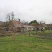
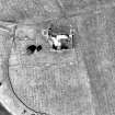
Threipmuir farmstead is situated in improved pasture on the lower slopes of the Pentland Hills, approximately 100m W of the dam separating Harlaw and Threipmuir Reservoirs. The ground slopes gently W and S towards the reservoir giving good natural drainage, but the water table is high and the area SW of the farmstead is particularly wet and marshy. The farmstead is a simple U-shaped Improved 18th century steading, comprising a long, single storey range on the S side with two free-standing outbuildings to the W and E. It is enclosed on its S side by a garden wall which overlies the remains of a larger (earlier) tree-lined enclosure. The larger enclosure overlies a small remnant of rig and furrow, extending S to the reservoir. On its N side, the farmstead is enclosed by a modern fence and there is a small clamp kiln for lime making about 100m to the NW.
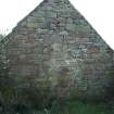
The S range is aligned E-W and has been built on a slope so that the E end is at least a metre higher than the W end. It has been extended and altered several times, but presently comprises eight distinct units, including a dwelling house (latterly, two cottages), byre, stable and cart shed, and is currently used for storage. Corrugated iron panels form a flat roof over the central portion of the range, with the remnants of a double pitched pantile roof at each end patched with corrugated iron. The E end is roofless and derelict and the rest of the structure is in poor repair particularly at the W end where the pitched roof has separated from both gable ends and is supported only by its central ridge beam. The W outbuilding was built as a threshing barn with opposed entrances (one of which is blocked), but subsequently modernised by the addition of a horse engine platform on its W side. Both gables and the W wall stand to wall head height, but the E wall is reduced to knee height. The E outbuilding is reduced to low footings and its function is not known.
A creation date of 1773/4 for the farmstead is known because a tenancy agreement of that date records that Sir Charles Scott agreed to build a suitable house for the Sheills family as part of a new farming venture. The earliest structure visible today is the western end of the S range, which was probably the original farmhouse and byre. The W outbuilding also dates to the late 18th century and although the E outbuilding cannot be dated it is likely to be broadly contemporary with the others. The original farmsteading probably formed an L-shape with the longer arm being the house and the short stub the barn.
Some original stonework survives in the gable end corners and rear wall of the house. These gable ends indicate that the wallhead of the original structure was wide enough to form a base suitable for a turf roof. The roof height was later raised, presumably to accommodate re-roofing in pantiles although this heavier roof pushed out the walls of the house and external buttresses now provide wall support. Buttresses outside the W outhouse or barn suggest this building had a similar problem and may also have had a pantile roof. More recently the majority of the tiles have been replaced by the flat roof seen today.
Threipmuir prospered throughout the late 18th and early 19th centuries. The south range was extended eastwards on 3 separate occasions and the frontage remodelled in a new style probably in the mid 19th century. The final extension, built over the ruined foundations of the E outbuilding, was complete by 1852 and is visible in a postcard photograph stamped 1914.
The Sheills family farmed Threipmuir until at least 1841. The house was in a poor state of repair in 1851 but it remained a working farm until at least 1861. At this date it had 3 rooms with windows but by 1871 it was only a 2 roomed shepherd’s cottage. In 1893 it was unroofed and derelict but by 1901 was reoccupied again by a shepherd. Plans are currently in progress for a restoration project for use as a community workshop.
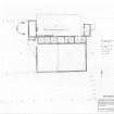
The buildings and their chronology are described in detail in the documents, Threipmuir Detailed Site Description and Threipmuir History, and these should be read in conjunction with the measured survey of the farmstead.
Information from SRP Pentland Hills, March 2010.
Field Visit (May 2008 - June 2008)
Plane table survey undertaken during two Scotland's Rural Past training days, May-June 2008. Further analysis of building chronology undertaken 2008-9.
Reference (May 2008 - November 2009)
Review of historic maps, printed material and archive sources, including estate papers and census records.
Excavation (22 April 2018 - 14 October 2018)
NT 1794 6429 A programme of archaeological work was undertaken intermittently, 22 April – 14 October 2018. The earliest part of Threipmuir Farm was built in 1773, initially as a short linear E/W range. This range was subsequently extended at least twice and two N/S buildings were added on the N side of each end. The area of land occupied by the farm had been commonty until 1768. Threipmuir Farm was extensively studied as part of The RCAHMS Scotland’s Rural Past Project.
At the time of the SRP study the buildings were very ruinous and the roofs particularly so. The centre part of the main range had been badly damaged by fire c1950 and replaced by virtually flat corrugated iron. The surviving pantiled sections were also very dangerous. Between 2011 and 2016 24m of roof, covering 6 apartments, was replaced with pitched corrugated iron conforming to the original profile of the pantile roof. The buildings are now used by Youth Vision, a local charity.
The farm originally had mixed use (the original tack document still exists). When Threipmuir reservoir was completed in the late 1840s a significant area of the farm was inundated. The 1851 census records a shepherd and housekeeper in residence.
The W N/S barn looks to have been a winnowing barn originally but a horse engine was added to its W side probably around 1800. It probably drove a threshing machine within the barn. However, the building of the reservoirs changed the nature of the agriculture of the farm rendering this machine redundant and the building is shown roofless on a map of 1843.
Over the years odd bits of gearing, no doubt related to the horse engine, have turned up randomly, and it was felt that a comprehensive excavation of the building would be of interest, given its early date of abandonment. The structure survives as three broad mortar-bonded piers on the S, W and N sides of the ‘circular’ structure. These would have supported the roof along with the wall of the W barn. The spaces between the piers would have allowed access to the interior of the building. As is typical with many ruined rural buildings, the ‘gin’ has been used as a dump for waste. This was to ensure broken glass, pottery etc were kept clear of animals and children.
Excavation began with the opening of a 2m wide trench between the N and S piers, a total length of 7.2m. This trench was initially subdivided into 4 sondages. The overburden measured 0.5 – 0.6m deep before the small compact cobbling of the horse walk was encountered. It consisted mainly of randomly dumped material varying from a dark humic soil to gritty and sandy clay deposits. Included in the dumped deposits was a myriad of mainly household refuse including enamelled kitchen ware, sherds of pottery, glass bottles, cutlery etc. Clearance of the upper level of the main trench revealed a crude, but deliberate, stone platform on its E side. This is thought to have been a stack stance for winter feed after the gin went out of use.
Further excavation uncovered a ceramic field drain emanating from under the stack stance and running diagonally across the gin floor to exit in the NW corner. The field drain had been laid on top of the cobbled horse walk and was of the extruded type as opposed to the old horseshoe and separate footplate type. Extruded field drain pipes were patented in c1845, which fits in nicely with post-gin use. A flat, thick flagstone with a sub-rectangular recess cut into it was uncovered in the centre of the gin. This presumably held the lower pivot point for a central post which would have had gearing on top linked to an overhead drive into the threshing machine in the W barn. Many of the later horse gins had low level drives which were connected to the operating machinery via a channel below ground level. The NW gap between the piers has been partially filled with rubble built ‘walling’ but the function of this is yet to be determined. There was also evidence that the NW quadrant of the gin may have been used for ironworking, as slag was found in the area, although this may also derive from dumping. None of the glass so far recovered looks to be any earlier than about 1840 – 50, confirming the post-gin dump. A complete clay tobacco pipe bowl stamped ‘TW’, Thomas Whyte, was recovered. This company operated in Edinburgh’s Canongate from 1825 till its demise in 1870.
Archive: TBD
Funder: Youth Vision and EAFS
K Robin Murdoch – Edinburgh Archaeological Field Society (EAFS)
(Source: DES Vol 19)
Excavation (July 2019 - November 2019)
NT 1794 6429 A second season of excavation was held from July to November 2019, starting with a general tidy up of the site and removal of protective coverings. The previous season (DES 2018, 76-7) had seen a start made to excavating the NW quadrant and this was recommenced. The remainder of the ceramic field drain was uncovered and found to be held in line by small stones. A 1m wide baulk running E-W from the centre of the building was left untouched until the areas N and S of it were excavated. This was to enable section drawings to be created in case any informative stratification was present. Given the nature of the deposits so far, at least in the western half of the building, this is looking unlikely.
Once the sections were drawn the E-W baulk was removed and comprehensive cleaning of the cobbled horse walk accomplished. The midden deposits removed from the western half of the building were very similar to that from last season. A multitude of domestic waste, i.e. crockery, glass, utensils and general bric-a- brac were recovered along with some slightly more substantial items which may have related to farming activities or the mill itself. The finds appear to date to the period c.1850 – c.1950 when the cottage was a permanent shepherd’s residence.
K R Murdoch - Edinburgh Archaeological Field Society
(Source: DES Vol 20)
Excavation (4 August 2021 - 13 October 2021)
NT 1794 6429 After a year of inactivity, the excavation was resumed by clearing the extensive weed growth between the cobbles of the horse walk and excavating a rectangular rubbish pit, which contained many finds of a domestic nature including ceramics, glassware, and a 303 bullet casing. A mound of soil was investigated which yielded a few domestic finds which included a cut glass decanter stopper, a poker and some sheep teeth. The mound is thought to be spoil from the digging of the pit and had been deposited directly on the cobbled surface. A 1m section was cut into the stack stance to the E of the horse engine, which produced more domestic finds, and the cobbled surface of the horse walk. Finally, a small cut was made outside the later boundary wall but no evidence for continuation of the main drain was found. The finds were all mid-19th to 20th-century origin. The earliest date obtained was 1850 from a “Syria” pattern plate by Cochran of Glasgow.
Archive: NRHE and City of Edinburgh Council HER
Funder: Edinburgh Archaeological Field Society; Youth Vision Balerno
Ian Hawkins – Edinburgh Archaeological Field Society
(Source: DES Vol 22)
Excavation (2022)
NT 1794 6429 In 2022 the excavation area was enlarged eastwards by a further metre taking it as close as possible to the W wall of the threshing barn. It is possible that the threshing barn will be rebuilt and, in that case, the excavation can be extended to its W wall, but currently the outward lean of that wall makes conditions unsafe. The finds turned out to be as before, mainly domestic rubbish from the occupation of the cottage as a shepherd’s dwelling between c1850 and c1950. Further excavation of what was originally thought to be a stack stance for winter feed revealed a straight eastern edge, which might change interpretation of that feature. Certainly, it is becoming clear that the horse gin area had a secondary function before ending up simply as a dump for domestic waste.
Archive: NRHE and City of Edinburgh Council HER
Funder: Edinburgh Archaeological Field Society, Youth Vision, Balerno
K Robi(Source: DES Volume 23)n Murdoch – Edinburgh Archaeological Field Society

