
Dron Hill


Fort (Period Unassigned), Plantation Bank (Period Unassigned)
Site Name Dron Hill
Classification Fort (Period Unassigned), Plantation Bank (Period Unassigned)
Canmore ID 30626
Site Number NO23SE 2
NGR NO 2891 3210
Datum OSGB36 - NGR
Permalink http://canmore.org.uk/site/30626


- Council Perth And Kinross
- Parish Longforgan (Perth And Kinross)
- Former Region Tayside
- Former District City Of Dundee
- Former County Perthshire
NO23SE 2 2891 3210.
(NO 2891 3210) Fort (NR)
OS 6" map (1902)
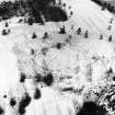
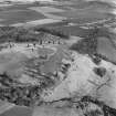
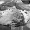
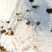
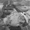
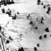
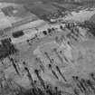
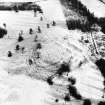
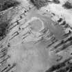
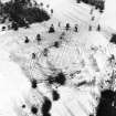
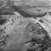
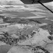
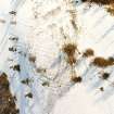
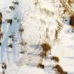
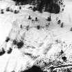
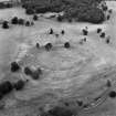
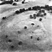
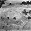
An oval fort at 648' OD on Dron Hill, measures 330' x 250' overall with a small crescentic annexe to the N, and another large one to the S, springing from the same points of the oval.
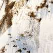
The greatly dilapidated wall of the fort is generally grass-covered, but on the W side is a 100' row of large stones, closely set, probably the base of the outer face of a wall, the inner face of which is represented by a less complete row, 9' - 10' distant. Basal stones also occur on the S side, where the mound is 27' wide. The N and E sides have been almost completely destroyed.
The enclosing mounds of the annexes are not defensive. They are very low, only 6' or 7' wide, and are probably ruined walls.
D Christison 1900
The fort is generally as described by Christison. In addition to its main wall there are traces of three outer defences on the W, generally reduced to wall courses or scarps approximately 0.5m high. The main entrance is in the NW side and there may have been a second in the SE. The "annexes" are old field/plantation banks with which the entire work has been severely mutilated.
Resurveyed at 1:2500.
Visited by OS (RD) 5 February 1969
The fort is generally as described in previous field report. Apart from the later plantation banks, there is no sign of secondary occupation. Revised at 25".
Visited by OS (JM) 9 June 1976
Field Visit (22 April 1957)
This site was included within the RCAHMS Marginal Land Survey (1950-1962), an unpublished rescue project. Site descriptions, organised by county, are available to view online - see the searchable PDF in 'Digital Items'. These vary from short notes, to lengthy and full descriptions. Contemporary plane-table surveys and inked drawings, where available, can be viewed online in most cases - see 'Digital Images'. The original typecripts, notebooks and drawings can also be viewed in the RCAHMS search room.
Information from RCAHMS (GFG) 19 July 2013.
Note (11 May 2015 - 18 May 2016)
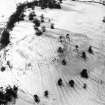
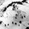
This fort is situated on the rounded summit of Dron Hill and has suffered heavily through the cultivation rigs driven across it from ENE to WSW and the successive plantation enclosures into which the greater part of the defences have been incorporated. Roughly oval on plan, but slightly flattened along its N arc, it measures internally about 98m from ESE to WNW by 73m transversely (0.55ha). The defences on the NW and SW comprise no fewer than three concentric stone ramparts, but only the inner can be traced round the rest of the circuit, with both faces surviving on the W, where it measures about 3m in thickness. There is an entrance on the WNW, where a shallow trackway pierces all three ramparts, and there is probably a second on the ESE. The interior is covered in broad sinuous rigs, which have been superseded by two plantations, the earlier of which is circular with its wall roughly following the line of the inner rampart around most of the circuit, and the later rhomboidal, embracing all the defences except those on the NW; the whole site was under trees in the mid 19th century.
Information from An Atlas of Hillforts of Great Britain and Ireland – 18 May 2016. Atlas of Hillforts SC3051

