
Carpow


Rig And Furrow (Medieval) - (Post Medieval), Ring Ditch (Period Unassigned)
Site Name Carpow
Classification Rig And Furrow (Medieval) - (Post Medieval), Ring Ditch (Period Unassigned)
Alternative Name(s) Carpow House Policies
Canmore ID 30104
Site Number NO21NW 45
NGR NO 20787 17853
Datum OSGB36 - NGR
Permalink http://canmore.org.uk/site/30104
Ordnance Survey licence number AC0000807262. All rights reserved.
Canmore Disclaimer.
© Copyright and database right 2024.
- Correction
- Favourite


DP 019084
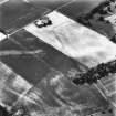
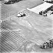
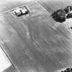
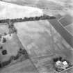
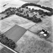
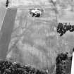
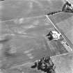
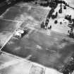
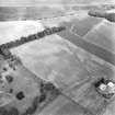
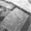
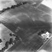
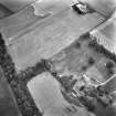
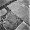
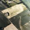
Oblique aerial view centred on the cropmarks of the Roman fortress and ring-ditch with the country house, farmhouse and farmsteading adjacent, taken form the NNW.
RCAHMS Aerial Photography Digital
17/7/2006
© Crown Copyright: HES

DP 019086
Oblique aerial view centred on the cropmarks of the Roman fortress and ring-ditch with the country house, farmhouse and farmsteading adjacent, taken form the W.
RCAHMS Aerial Photography Digital
17/7/2006
© Crown Copyright: HES

DP 019087
Oblique aerial view centred on the cropmarks of the Roman fortress with the farmhouse and farmsteading adjacent, taken form the W.
RCAHMS Aerial Photography Digital
17/7/2006
© Crown Copyright: HES

DP 050721
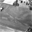
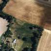
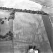
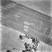
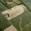
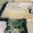
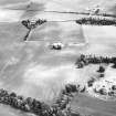
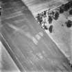
Oblique aerial view of the cropmarks of the ring ditch, legionary fortress and rig and furrow at Carpow with the Carpow House adjacent, taken from the SSE.
RCAHMS Aerial Photography Digital
23/7/2008
© Crown Copyright: HES

DP 050723
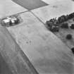
Oblique aerial view of the cropmarks of the ring ditch, legionary fortress and rig and furrow at Carpow with the farmsteading adjacent, taken from the NW.
RCAHMS Aerial Photography Digital
23/7/2008
© Crown Copyright: HES

SC 1711528
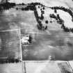
Internal buildings visible
RCAHMS Aerial Photography
1989
© Crown Copyright: HES


SC 1711688
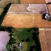
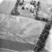
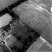
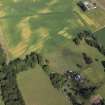
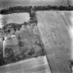
Carpow and Gillies Burn, oblique aerial view, taken from the NE, centred on the cropmarks of a Roman Fort, a Roman enclosure and an unenclosed settlement. The cropmarks of a Roman aqueduct and a ring-ditch, and Mains of Carpow farmsteading are visible in the top half of the photograph, and linear cropmarks are shown in the bottom centre half.
12/7/1996
© RCAHMS


SC 2400437
Carpow, NO21NW 45, Ordnance Survey index card, page number 2, Recto
Records of the Ordnance Survey, Southampton, Hampshire, England
1958
© Crown Copyright: HES (Ordnance Survey Archaeology Division Collection)


DP 019088
Oblique aerial view centred on the cropmarks of the Roman fortress and ring-ditch with the country house, farmhouse and farmsteading adjacent, taken form the NW.
RCAHMS Aerial Photography Digital
17/7/2006
© Crown Copyright: HES


SC 1711527
Internal buildings visible
RCAHMS Aerial Photography
1989
© Crown Copyright: HES

SC 1711549
Internal buildings visible
RCAHMS Aerial Photography
1989
© Crown Copyright: HES


SC 1711596
Oblique aerial view.
RCAHMS Aerial Photography
28/6/1994
© Crown Copyright: HES


SC 1711608
Oblique aerial view.
RCAHMS Aerial Photography
10/8/1994
© Crown Copyright: HES

SC 1711689
Carpow and Gillies Burn, oblique aerial view, taken from the NNW, centred on the cropmarks of a Roman Fort, a Roman enclosure, a ring-ditch and an unenclosed settlement. Mains of Carpow farmsteading is visible in the top right-hand corner of the photograph, and linear cropmarks are shown in the bottom left-hand corner.
12/7/1996
© RCAHMS

SC 1711690
Carpow and Gillies Burn, oblique aerial view, taken from the WNW, centred on the cropmarks of a Roman Fort, a Roman enclosure, ring-ditch and an unenclosed settlement. Mains of Carpow farmsteading is visible in the centre right half of the photograph.
12/7/1996
© RCAHMS

SC 1711692
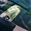
Carpow and Gillies Burn, oblique aerial view, taken from the SE, centred on the cropmarks of a Roman Fort, a Roman enclosure, ring-ditch and an unenclosed settlement. Mains of Carpow farmsteading is visible in the bottom left-hand corner of the photograph.
12/7/1996
© RCAHMS


SC 1711530
Internal buildings visible
RCAHMS Aerial Photography
1989
© Crown Copyright: HES


SC 1711603
Oblique aerial view.
RCAHMS Aerial Photography
28/6/1994
© Crown Copyright: HES


SC 2400436
Carpow, NO21NW 45, Ordnance Survey index card, page number 1, Recto
Records of the Ordnance Survey, Southampton, Hampshire, England
1958
© Crown Copyright: HES (Ordnance Survey Archaeology Division Collection)

DP 019089
Oblique aerial view centred on the cropmarks of the Roman fortress and ring-ditch with the country house, farmhouse and farmsteading adjacent, taken form the W.
RCAHMS Aerial Photography Digital
17/7/2006
© Crown Copyright: HES

SC 1208147
Internal buildings visible
RCAHMS Aerial Photography
1989
© Crown Copyright: HES


SC 1711548
Internal buildings visible
RCAHMS Aerial Photography
1989
© Crown Copyright: HES

SC 1711594
Oblique aerial view.
RCAHMS Aerial Photography
28/6/1994
© Crown Copyright: HES

SC 1711595
Oblique aerial view.
RCAHMS Aerial Photography
28/6/1994
© Crown Copyright: HES

SC 1711599
Oblique aerial view.
RCAHMS Aerial Photography
28/6/1994
© Crown Copyright: HES

SC 1711607
Oblique aerial view.
RCAHMS Aerial Photography
10/8/1994
© Crown Copyright: HES


DP 050720
Oblique aerial view of the cropmarks of the ring ditch, legionary fortress and rig and furrow at Carpow, taken from the S.
RCAHMS Aerial Photography Digital
23/7/2008
© Crown Copyright: HES

DP 050722
Oblique aerial view of the cropmarks of the ring ditch, legionary fortress and rig and furrow at Carpow with the Carpow House adjacent, taken from the NNW.
RCAHMS Aerial Photography Digital
23/7/2008
© Crown Copyright: HES

SC 1711529
Internal buildings visible
RCAHMS Aerial Photography
1989
© Crown Copyright: HES

SC 1711552
Internal buildings visible
RCAHMS Aerial Photography
1989
© Crown Copyright: HES

SC 1711598
Oblique aerial view.
RCAHMS Aerial Photography
28/6/1994
© Crown Copyright: HES


SC 2400435
Carpow, NO21NW 45, Ordnance Survey index card, Recto
Records of the Ordnance Survey, Southampton, Hampshire, England
1958
© Crown Copyright: HES (Ordnance Survey Archaeology Division Collection)

DP 019085
Oblique aerial view centred on the cropmarks of the Roman fortress and ring-ditch with the country house, farmhouse and farmsteading adjacent, taken form the NW.
RCAHMS Aerial Photography Digital
17/7/2006
© Crown Copyright: HES

DP 050719
Oblique aerial view of the cropmarks of the ring ditch, legionary fortress and rig and furrow at Carpow with the farmsteading adjacent, taken from the WSW.
RCAHMS Aerial Photography Digital
23/7/2008
© Crown Copyright: HES


SC 1711550
Internal buildings visible
RCAHMS Aerial Photography
1989
© Crown Copyright: HES

SC 1711551
Internal buildings visible
RCAHMS Aerial Photography
1989
© Crown Copyright: HES


SC 1711691
Carpow and Gillies Burn, oblique aerial view, taken from the SW, centred on the cropmarks of a Roman Fort, a Roman enclosure, ring-ditch and an unenclosed settlement. Mains of Carpow farmsteading and the cropmarks of a Roman aqueduct are visible in the bottom half of the photograph.
12/7/1996
© RCAHMS


SC 1711597
Oblique aerial view.
RCAHMS Aerial Photography
28/6/1994
© Crown Copyright: HES


- Council Perth And Kinross
- Parish Abernethy (Perth And Kinross)
- Former Region Tayside
- Former District Perth And Kinross
- Former County Perthshire
NO21NW 45 20787 17833
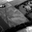
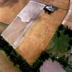
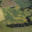
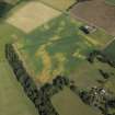
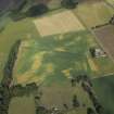
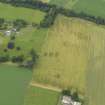
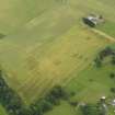
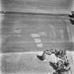
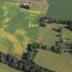
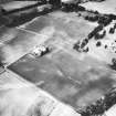
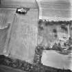
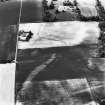
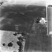
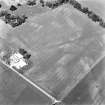
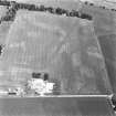
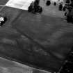
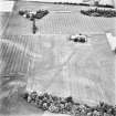
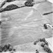
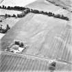
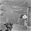
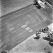
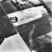
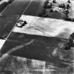
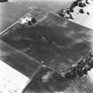
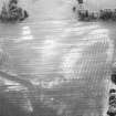
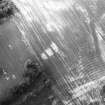
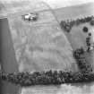
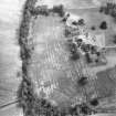
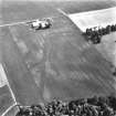
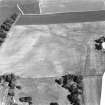
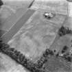
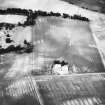
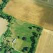
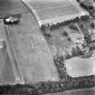
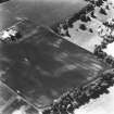
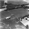
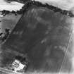
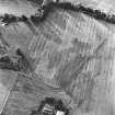
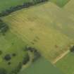
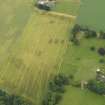
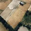
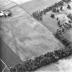
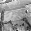
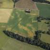
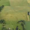
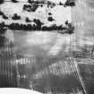
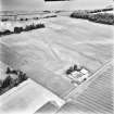
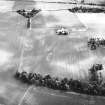
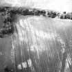
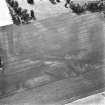
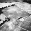
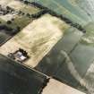
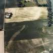
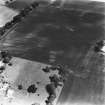
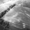
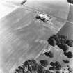
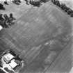
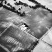
Aerial photography (RCAHMSAP 1976, 1978, 1981, 1982, 1983, 1986, 1989, 1992. 1994 and 1996) has recorded the cropmarks of a penannular ring-ditch about 180m E of Carpow House (NO21NW 66.00). It measures about 5m in diameter within a broad ditch and has an entrance-gap on the S.
Information from RCAHMS (JRS), 4 February 1997.
Aerial Photographic Transcription (31 December 1993)
An aerial transcription was produced from oblique aerial photographs. Information from Historic Environment Scotland (BM) 31 March 2017.

