
Markinch Hill


Cultivation Terrace(S) (Period Unassigned)
Site Name Markinch Hill
Classification Cultivation Terrace(S) (Period Unassigned)
Canmore ID 29949
Site Number NO20SE 11
NGR NO 2975 0225
NGR Description Centred NO 2975 0225
Datum OSGB36 - NGR
Permalink http://canmore.org.uk/site/29949


- Council Fife
- Parish Markinch
- Former Region Fife
- Former District Kirkcaldy
- Former County Fife
NO20SE 11 centred 2975 0225
(NO 2975 0225) Terraces (NR)
OS 6" map 81938)
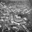
These six cultivation terraces, on the NW face of Markinch Hill, extend for about 300 yds. They have an average breadth of 20' and are from 10' - 12' high. Today they form a series of footpaths and their original outlines have been altered to some extent.
RCAHMS 1933, visited 1925; A Graham 1939.
The cultivation terraces are as described although they are covered by thick rhododendrons.
Visited by OS (JP) 21 June 1974.
Field Visit (17 June 1925)
Terraces, Markinch Hill.
These remarkable terraces, lying on the north side of the town at an elevation of 300 feet above sea-level, have been the subject of much speculation, but no conclusive explanation of their origin has, as yet, been framed. The late Dr. Laing asserted that they were designed as an arena for spectators to witness the sports and contests of mediaeval times on the field at their base, which now forms part of a golf-course and still retains the old name of "The Playfield" (1). The New Statistical Account (2) says: "They overlook a level field of about twelve acres, which before being drained, must have formed an impassable morass. There is no definite tradition why or when these terraces were formed." They are six in number and extend for a distance of approximately 300 yards in a line running northeast and south-west. They have an average breadth of 20 feet and are from 10 to 12 feet high, rising one above the other irregular gradation. They have now been converted into a series of public foot-paths, and their original outlines are therefore to some extent altered although the general plan remains unchanged. At the north-east extremity of the hill the remains of five terraces are apparent, but two of these merge into each other about 175 yards towards the south-west, while a sixth terrace becomes visible at a higher level. At the south-west end the terraces are reduced to four in consequence of the natural fall in the ground.
RCAHMS 1933, visited 17 June 1925.
(1) Lindores Abbey and its Burgh of Newburgh, p. 5, footnote. (2) Vol. ix (1840), p. 663.

