
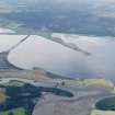
Meikle Ferry, East Pier


Pier (Period Unassigned)
Site Name Meikle Ferry, East Pier
Classification Pier (Period Unassigned)
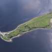
Alternative Name(s) Ferery Point; Ness Of Portnaculter; Ness Of Portnaculter; Dornoch Firth
Canmore ID 299180
Site Number NH78NW 65
NGR NH 73242 85931
Datum OSGB36 - NGR
Permalink http://canmore.org.uk/site/299180


- Council Highland
- Parish Tain
- Former Region Highland
- Former District Ross And Cromarty
- Former County Ross And Cromarty
NH78NW 65 73242 85931
Pier [NAT]
OS (GIS) MasterMap, June 2009.
For West Pier (NH 73212 85922), see NH78NW 31.
For Ferry, see also NH78NW 34.
For corresponding pier on the N side of the Dornoch Firth, at Meikle Ferry or Ferrytown, see NJ78NW 28.

