
Rossie Drain


Enclosure (Period Unassigned)
Site Name Rossie Drain
Classification Enclosure (Period Unassigned)
Alternative Name(s) Shiells
Canmore ID 29789
Site Number NO20NE 31
NGR NO 28069 09929
Datum OSGB36 - NGR
Permalink http://canmore.org.uk/site/29789
Ordnance Survey licence number AC0000807262. All rights reserved.
Canmore Disclaimer.
© Copyright and database right 2024.
- Correction
- Favourite

DP 153844
Oblique aerial view of the cropmarks of the rig and enclosure at Rossie Drain, looking to the NNE.
RCAHMS Aerial Photography Digital
17/5/2013
© Crown Copyright: HES

SC 1711289
Oblique aerial view of Rossie Drain centred on the cropmarks of an enclosure with cropmrks of ring-ditches and rig adjacent, taken from the SSW.
RCAHMS Aerial Photography
19/7/1999
© Crown Copyright: HES


DP 311148
Oblique aerial view
Historic Environment Scotland
16/7/2019
© Historic Environment Scotland


DP 407306
Oblique Aerial View
Historic Environment Scotland
20/6/2023
© Historic Environment Scotland

DP 008935
Oblique aerial view centred on the cropmarks of the enclosure and rig, taken from the W.
RCAHMS Aerial Photography Digital
12/7/2005
© Crown Copyright: HES

DP 153849
Oblique aerial view of the cropmarks of the rig and enclosure at Rossie Drain, looking to the SSW.
RCAHMS Aerial Photography Digital
17/5/2013
© Crown Copyright: HES


SC 1711277
Oblique aerial view centred on the cropmarks of an enclosure, taken from the SE.
RCAHMS Aerial Photography
15/6/1999
© Crown Copyright: HES


DP 311147
Oblique aerial view
Historic Environment Scotland
16/7/2019
© Historic Environment Scotland

DP 311149
Oblique aerial view
Historic Environment Scotland
16/7/2019
© Historic Environment Scotland

SC 2399787
Rossie Drain, NO20NE 31, Ordnance Survey index card, Recto
Records of the Ordnance Survey, Southampton, Hampshire, England
1958
© Crown Copyright: HES (Ordnance Survey Archaeology Division Collection)

DP 407316
Oblique Aerial View
Historic Environment Scotland
20/6/2023
© Historic Environment Scotland

DP 162498
Oblique aerial view of the cropmarks of the ring ditch and rig at Rossie Drain, looking SW.
RCAHMS Aerial Photography Digital
26/6/2013
© Crown Copyright: HES


SC 1711245
Rossie Drain: aerial view of cropmarks.
RCAHMS Aerial Photography
19/7/1994
© Crown Copyright: HES

SC 1711246
Rossie Drain: aerial view of cropmarks.
RCAHMS Aerial Photography
19/7/1994
© Crown Copyright: HES

SC 1711248
Rossie Drain: aerial view of cropmarks.
RCAHMS Aerial Photography
19/7/1994
© Crown Copyright: HES

SC 1711276
Oblique aerial view centred on the cropmarks of an enclosure, taken from the SW.
RCAHMS Aerial Photography
15/6/1999
© Crown Copyright: HES

SC 1711296
Oblique aerial view centred on the cropmarks of the enclosure and rig, taken from the E.
RCAHMS Aerial Photography
20/6/2000
© Crown Copyright: HES


DP 407305
Oblique Aerial View
Historic Environment Scotland
20/6/2023
© Historic Environment Scotland

DP 407311
Oblique Aerial View
Historic Environment Scotland
20/6/2023
© Historic Environment Scotland


SC 1711272
Oblique aerial view centred on the cropmarks of the enclosure with rig adjacent, taken from the SSE.
RCAHMS Aerial Photography
7/7/1998
© Crown Copyright: HES


DP 407309
Oblique Aerial View
Historic Environment Scotland
20/6/2023
© Historic Environment Scotland


SC 1711278
Oblique aerial view centred on the cropmarks of an enclosure, taken from the E.
RCAHMS Aerial Photography
15/6/1999
© Crown Copyright: HES

SC 1711293
Oblique aerial view centred on the cropmarks of the enclosure and rig, taken from the SW.
RCAHMS Aerial Photography
20/6/2000
© Crown Copyright: HES

SC 1711294
Oblique aerial view centred on the cropmarks of the enclosure and rig, taken from the SSE.
RCAHMS Aerial Photography
20/6/2000
© Crown Copyright: HES

SC 1711295
Oblique aerial view centred on the cropmarks of the enclosure and rig, taken from the SE.
RCAHMS Aerial Photography
20/6/2000
© Crown Copyright: HES

DP 311150
Oblique aerial view
Historic Environment Scotland
16/7/2019
© Historic Environment Scotland

DP 008933
General oblique aerial view centred on the cropmarks of the enclosure and rig, taken from the NNW.
RCAHMS Aerial Photography Digital
12/7/2005
© Crown Copyright: HES

DP 153852
Oblique aerial view of the cropmarks of the rig and enclosure at Rossie Drain, looking to the E.
RCAHMS Aerial Photography Digital
17/5/2013
© Crown Copyright: HES

DP 162496
Oblique aerial view of the cropmarks of the ring ditch and rig at Rossie Drain, looking NW.
RCAHMS Aerial Photography Digital
26/6/2013
© Crown Copyright: HES


SC 1711239
Rossie Drain: aerial view of cropmarks.
RCAHMS Aerial Photography
19/7/1994
© Crown Copyright: HES

SC 1711244
Rossie Drain: aerial view of cropmarks.
RCAHMS Aerial Photography
19/7/1994
© Crown Copyright: HES

SC 1711249
Rossie Drain: aerial view of cropmarks.
RCAHMS Aerial Photography
19/7/1994
© Crown Copyright: HES

SC 1711274
Oblique aerial view centred on the cropmarks of the enclosure with rig adjacent, taken from the ESE.
RCAHMS Aerial Photography
7/7/1998
© Crown Copyright: HES

SC 1711288
Oblique aerial view of Rossie Drain centred on the cropmarks of an enclosure with cropmarks of ring-ditches and rig adjacent, taken from the S.
RCAHMS Aerial Photography
19/7/1999
© Crown Copyright: HES


DP 407310
Oblique Aerial View
Historic Environment Scotland
20/6/2023
© Historic Environment Scotland

DP 008936
General oblique aerial view centred on the cropmarks of the enclosure and rig, taken from the W.
RCAHMS Aerial Photography Digital
12/7/2005
© Crown Copyright: HES

DP 153850
Oblique aerial view of the cropmarks of the rig and enclosure at Rossie Drain, looking to the S.
RCAHMS Aerial Photography Digital
17/5/2013
© Crown Copyright: HES

DP 153851
Oblique aerial view of the cropmarks of the rig and enclosure at Rossie Drain, looking to the SSE.
RCAHMS Aerial Photography Digital
17/5/2013
© Crown Copyright: HES


SC 1711240
Rossie Drain: aerial view of cropmarks.
RCAHMS Aerial Photography
19/7/1994
© Crown Copyright: HES

SC 1711271
Oblique aerial view centred on the cropmarks of the enclosure with rig adjacent, taken from the S.
RCAHMS Aerial Photography
7/7/1998
© Crown Copyright: HES

SC 1711273
Oblique aerial view centred on the cropmarks of the enclosure with rig adjacent, taken from the SE.
RCAHMS Aerial Photography
7/7/1998
© Crown Copyright: HES

SC 1711287
Oblique aerial view of Rossie Drain centred on the cropmarks of an enclosure with cropmarks of ring-ditches and rig adjacent, taken from the S.
RCAHMS Aerial Photography
19/7/1999
© Crown Copyright: HES


SC 2399786
Rossie Drain, NO20NE 31, Ordnance Survey index card, Recto
Records of the Ordnance Survey, Southampton, Hampshire, England
1958
© Crown Copyright: HES (Ordnance Survey Archaeology Division Collection)

DP 407307
Oblique Aerial View
Historic Environment Scotland
20/6/2023
© Historic Environment Scotland

DP 407308
Oblique Aerial View
Historic Environment Scotland
20/6/2023
© Historic Environment Scotland


SC 1711241
Rossie Drain: aerial view of cropmarks.
RCAHMS Aerial Photography
19/7/1994
© Crown Copyright: HES

SC 1711275
Oblique aerial view centred on the cropmarks of an enclosure, taken from the W.
RCAHMS Aerial Photography
15/6/1999
© Crown Copyright: HES


SC 2399788
Rossie Drain, NO20NE 31, Ordnance Survey index card, Recto
Records of the Ordnance Survey, Southampton, Hampshire, England
1958
© Crown Copyright: HES (Ordnance Survey Archaeology Division Collection)

DP 407312
Oblique Aerial View
Historic Environment Scotland
20/6/2023
© Historic Environment Scotland


- Council Fife
- Parish Collessie
- Former Region Fife
- Former District North East Fife
- Former County Fife
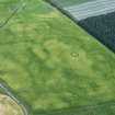
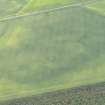
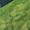
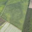
NO20NE 31 2815 0987.
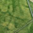
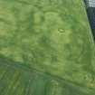
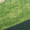
The site first appeared in 1977 APs as an enclosure with an entrance to the NE. Further APs taken in 1977 and 1985 show a similar enclosure but with a possible internal feature. These may be the same site as the cropmarks vary considerably in this field from year to year.
A F Harding and G E Lee 1987.
Aerial photography has revealed the cropmark of an enclosure on a low rise in a field to the SW of a dismantled railway, some 860m to the N of Shiells Farm. It measures about 20m in diameter within a broad ditch and has an entrance on the NE. It is plotted on a distribution map of henge monuments and penannular ring-ditces covering southern Scotland (RCAHMS 1994, 39, fig. A; RCAHMS 1997, 116, fig. 111).
Information from RCAHMS (ARG) 30 September 1997.

