
Rossie Drain


Rig And Furrow (Medieval) - (Post Medieval), Ring Ditch(S) (Period Unassigned)
Site Name Rossie Drain
Classification Rig And Furrow (Medieval) - (Post Medieval), Ring Ditch(S) (Period Unassigned)
Alternative Name(s) Easter Kilwhiss
Canmore ID 29782
Site Number NO20NE 25
NGR NO 28031 09850
Datum OSGB36 - NGR
Permalink http://canmore.org.uk/site/29782


- Council Fife
- Parish Collessie
- Former Region Fife
- Former District North East Fife
- Former County Fife
NO20NE 25 28067 09927
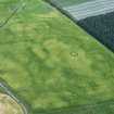
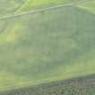
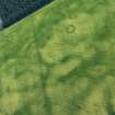
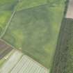
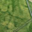
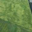
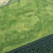
A scatter of ring-ditches and rig have been recorded as cropmarks on oblique aerial photography (RCAHMSAP 1978, 1979,1983, 1986, 1990, 1993, 1994, 1999, 2000) about 850m N of Shiells Farm. The rig covers a large area and is oriented roughly NE-SW; the ring-ditches lie within it. The enclosure recorded at NO20NE 31 lies within the rig.
Information from RCAHMS (KMM) 8 June 2004

