
Dundee, Craigie Avenue, Pillbox


Pillbox (20th Century)
Site Name Dundee, Craigie Avenue, Pillbox
Classification Pillbox (20th Century)
Alternative Name(s) Strips Of Craigie Road
Canmore ID 297214
Site Number NO43SW 1017
NGR NO 4329 3116
NGR Description c.NO 4329 3116
Datum OSGB36 - NGR
Permalink http://canmore.org.uk/site/297214


- Council Dundee, City Of
- Parish Dundee (Dundee, City Of)
- Former Region Tayside
- Former District City Of Dundee
- Former County Angus
NO43SW 1017 c.4329 3116
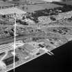
A WW II pillbox has been identified from a RAF WW II oblqiue air photograph taken in 1943 (NLA 66, frame no.0025, flown 2 July 1943), , situated on the S side of Craigie Avenue at the junction (round-a-bout) with Strips of Craigie Road. The pillbox formed part of a road block (NO43SW 1018) which covered Craigie Avenue.
The pillbox and road block have since been removed following the end of World War II.
Information from RCAHMS (DE), December 2008

