
Dalgety, Old Harbour, Bombing Target Arrow


Bombing Range Marker (20th Century)
Site Name Dalgety, Old Harbour, Bombing Target Arrow
Classification Bombing Range Marker (20th Century)
Alternative Name(s) Dalgety Bay
Canmore ID 297158
Site Number NT18SE 68
NGR NT 1639 8304
NGR Description NT c. 1639 8304
Datum OSGB36 - NGR
Permalink http://canmore.org.uk/site/297158


- Council Fife
- Parish Dalgety
- Former Region Fife
- Former District Dunfermline
- Former County Fife
NT18SE 68 c. 1639 8304
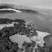
A concrete bombing target arrow has been identified from vertical air photographs taken in 1945 (106G/UK/983, frames 4347-4348, flown 8 November 1945), immediately E of the Old Dalgety harbour (NT18SE 16). Visible on the photograph, the concrete arrow, which points SE, has two small structures on each side.
The arrow remains visible on RAF vertical air photographs up to the 1955 series.
Information from RCAHMS (DE), November 2008.

