
Inverness, Huntly Place, West Free Church


Church (Period Unassigned)
Site Name Inverness, Huntly Place, West Free Church
Classification Church (Period Unassigned)
Alternative Name(s) Trinity Church; West United Free Church; St Marks West Church
Canmore ID 295765
Site Number NH64NE 808
NGR NH 66077 45786
Datum OSGB36 - NGR
Permalink http://canmore.org.uk/site/295765


- Council Highland
- Parish Inverness And Bona
- Former Region Highland
- Former District Inverness
- Former County Inverness-shire
NH64NE 808 66077 45786
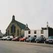
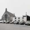
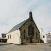
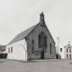
Former Free Church situated on the W side of Huntly Place. Originally rectangular in plan, later additionas to rear and S side, with slated roof and bellcote at E end.
The church is depicted as roofed on the 1st edition of the OS 25-inch map (Inverness-shire, 1868-71, sheet) and annotated as the 'West Free Church'. By the date of the 2nd edition 25-inch (ibid, 1904-1905) it is annotated as 'West U.F. Church' and the Provisional Edition of the 1930's as' St Marks West Church'.
The current OS 1:2500 scale digital map annotates the building as 'Trinity Church'.
(Undated) information in NMRS.
Photographic Survey (7 April 2003)
Photographed by RCAHMS as part of the District Area Photographic Survey.
Note (September 2008)
Former Free Church situated on the W side of Huntly Place. Originally rectangular in plan, later additionas to rear and S side, with slated roof and bellcote at E end.
The church is depicted as roofed on the 1st edition of the OS 25-inch map (Inverness-shire, 1868-71, sheet) and annotated as the 'West Free Church'. By the date of the 2nd edition 25-inch (ibid, 1904-1905) it is annotated as 'West U.F. Church' and the Provisional Edition of the 1930's as' St Marks West Church'. The current OS 1:2500 scale digital map annotates the building as 'Trinity Church'.

